Link-11 SLEW with go2MONITOR

In early November, whilst working on an article for Janes, I noticed a Link-11 SLEW signal on 4510 kHz (CF) that was slowly growing in reception strength. I’d been monitoring frequencies used by the Northern Fleet of the Russian navy around this one and had already spotted that Link-11 CLEW was being used on a nearby frequency, though this remained at a constant signal strength at my location. The fact that the Link-11 SLEW was getting stronger made me stop what I was doing and start concentrating on this instead.

AirSpy HF+ Discovery SDR with SDRConsole operating software. Link-11 SLEW signal in Receiver 1, and the weaker Link-11 CLEW signal in Receiver 3. Whilst there a two SLEW signals showing, there is just one, with the left hand one being produced by the strong signal. You can see the weaker transmissions from a receiving station between the stronger ones on the correct frequency, but not on the “reflection”.

Link-11 SLEW (Single-Tone Link-11 waveform) ,or STANAG 5511, is a NATO Standard for tactical data exchange used between multiple platforms, be it on Land, Sea or Air. Its main function is the exchange of radar information, and in HF this is particularly useful for platforms that are beyond line of sight of each other and therefore cannot use the UHF version of Link-11.

With propagation being the way it is, in theory radar data could be exchanged between platforms that are hundreds to thousands of miles apart, therefore providing a wider picture of operations to other mobile platforms and fixed land bases. This data can also be forwarded on using ground stations that receive the data and then re-transmit on another frequency and/or frequency band. However, the approximate range of an individual broadcast on HF is reported to be 300nm.

As well as radar information, electronic warfare (EW) and command data can also be transmitted, but despite the capability to transmit radar data, it is not used for ATC purposes. In the UK, Link-11 is used by both the RAF (in E-3 AWAC’s and Tactical Air Control Centres) and the Royal Navy. Primarily it is used for sharing of Maritime data. Maritime Patrol Aircraft (MPA’s) such as USN P-8’s and Canadian CP-140’s use Link-11 both as receivers and transmitters of data, so when the RAF start using their P-8’s operationally in 2020 expect this to be added to the UK list. Whilst it is a secure data system, certain parameters can be extracted for network analysis and it can be subjected to Electronic Countermeasures (ECM).

Link-11 data is correlated against any tracks already present on a receivers radar picture. If a track is there it is ignored, whilst any that are missing are added but with a different symbol to show it is not being tracked by their own equipment. As this shared data is normally beyond the range of a ships own radar systems, this can provide an early warning of possible offensive aircraft, missiles or ships that would not normally be available.

I started up go2MONITOR and linked it to my WinRadio G31 Excalibur. Using a centre frequency of 4510 kHz I ran an emission search and selected the Link-11 SLEW modulation that it found at this frequency.

It immediately started decoding as much as it could, and I noticed that three Address ID’s were in the network.

go2MONITOR in action just after starting it up. Note, three ID’s in the network – 2_o, 30_o and 71_o

As the signal was strong, and it is normally maritime radar data that is being transmitted, I decided to have a quick look on AIS to see if there was anything showing nearby. Using AISLive I spotted that Norwegian navy Fridtjof Nansen class FFGHM Thor Heyerdahl was 18.5 nm SW of my location, just to the west of the island Ailsa Craig. Whilst it was using an incorrect name for AIS identification, its ITU callsign of LABH gave me the correct ID. This appeared to be the likely candidate for the strong Link-11 signal.

Position of Thor Heyerdahl from my AIS receiver using AISLive software

It wasn’t the best day and it was pretty murky out to sea with visibility being around 5nm – I certainly couldn’t see the Isle of Arran 11.5 nm away. I kept an eye on the AIS track for Thor Heyerdahl but it didn’t appear to be moving.

Whilst my own gear doesn’t allow me to carry out any Direction Finding (DF) I elected to utilise SDR.hu and KiwiSDR’s to see if I could get a good TDoA fix on a potential transmitter site – TDoA = Time Difference Of Arrival, also known as multilateration or MLAT. Whilst not 100% accurate, TDoA is surprisingly good and will sometimes get you to within a few kilometres of a transmission site with a strong signal.

One of my thoughts was that the signal was emanating from the UK Defence High Frequency Communications Service (DHFCS) site at either St. Eval in Cornwall or Inskip in Lancashire. With this in mind I picked relevant KiwiSDR’s that surrounded these two sites and my area and ran a TDoA.

St. Eval transmitter site at 50°28’43.0″N 4°59’58.0″W
Inskip transmitter site at 53°49’26.6″N 2°50’14.1″W

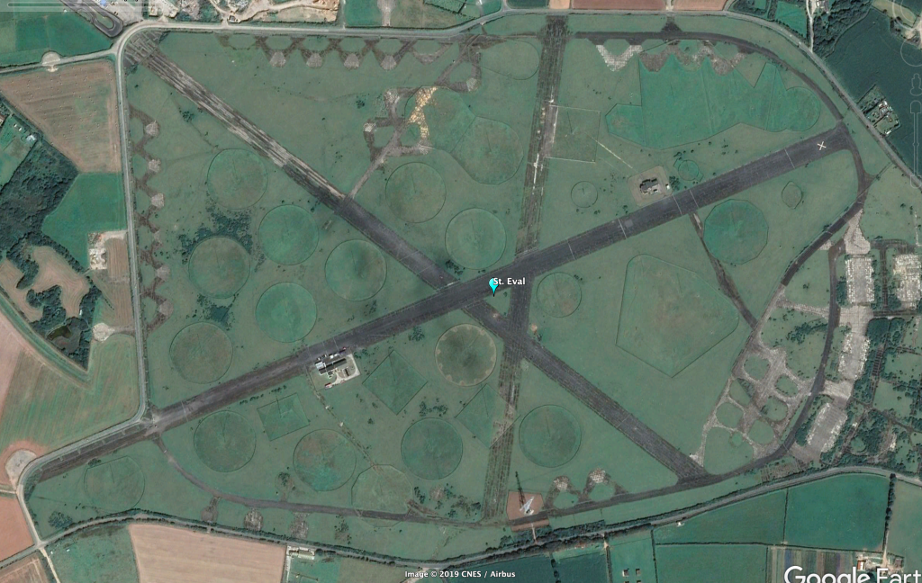
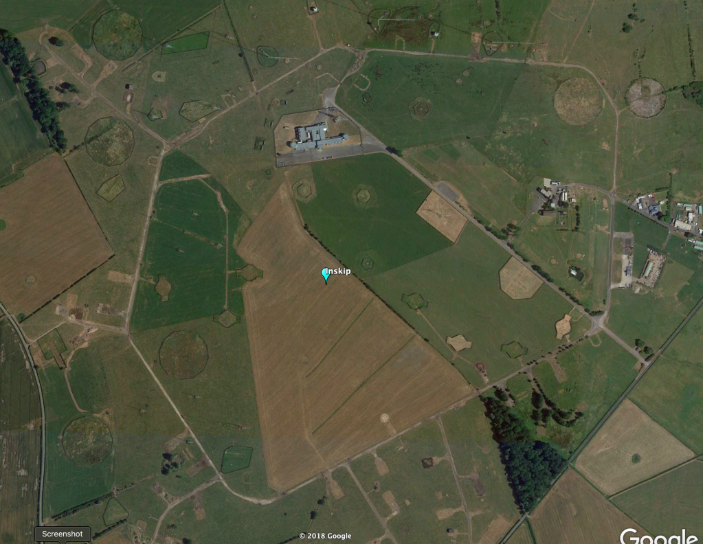
As expected, the result showed the probable transmitter site as just over 58 kilometres from St. Eval, though the overall shape and “hot area” of the TDoA map also covered Inskip, running along the West coast of England, Wales and Scotland. It peaked exactly in line to where the Norwegian navy ship and I were located! With the fact that there were signals being received from three different sources it is highly likely this has averaged out to this plot.

TDoA result showing the likely transmitter site at 50.60N 4.20W. Note the elongated “hot spot” which denotes the area that the transmitter site is likely to be situated.

Just after 10am the weather cleared allowing me to see a US Navy Arleigh Burke class DDGHM between myself and Arran. This added an extra ship to the equation, and also tied in with the TDoA hot spot. Things were getting even more interesting!

Link-11 SLEW at its strongest which also coincided with USS Gridley being its closest to my location.

Thor Heyerdahl still hadn’t moved according to AISLive but the Arleigh Burke was clearly heading in to the Royal Navy base at Faslane. With my Bearcat UBC-800T scanning the maritime frequencies it wasn’t long before “Warship 101” called up for Clyde pilot information along with an estimate for Ashton Buoy of 1300z. Warship 101 tied up with Arleigh Burke USS Gridley.

The Link-11 SLEW signal was considerably weaker at the time USS Gridley was at Ashton Buoy.

As USS Gridley progressed towards Faslane, the signal started to get weaker. Ashton Buoy is where most ships inbound for Faslane meet the pilot and tugs, taking up to another 30 minutes to get from there to alongside at the base – a journey of about 8.5nm.

At 1328z the Link-11 SLEW signal ended which coincided with the time that USS Gridley approached alongside at Faslane. It would be at about this time that most of the radar systems used on the ship would have been powered down so data was no longer available for transmission, therefore the Link-11 network was not required any further and it was disconnected.

The Link-11 SLEW signal disappeared at 1328z
Some images of USS Gridley arriving into Faslane taken by good friend Dougie Coull

So, was this Link-11 SLEW connected to USS Gridley? And was the ship also the NCS of the network? I think the answer is yes to both, and I’ll explain a couple of things that leads me to this conclusion. But first…………….

Link-11 SLEW Technical details

Using Upper Side Band (USB) in HF, a single waveform is generated in a PSK-8 modulated, 1800 Hz tone. The symbol rate is 2400 Bd and the user data rate is 1800 bps. Link-11 SLEW is an improved version of the older Link-11 CLEW modulation and due to enhanced error detection and correction is a more robust method of sending data. This makes it more likely that transmissions are received correctly the first time. Moreover, an adaptive system is used to counter any multipath signals the receiving unit may experience due to HF propagation.

The waveform transmission consists of an acquisition preamble followed by two or more fields, each of which is followed by a reinsertion probe. The field after the preamble is a header field containing information that is used by the CDS (Combat Data System) and an encryptor. If a network Participating Unit (PU) has any data, for instance track data, this follows the reinsertion probe. Finally, an end-of-message (EOM) is sent followed by a reinsertion probe.

The header is made up of 33 data bits and 12 error detection bits (CRC – Cyclic Redundancy Check). The 45 bit sequence is encoded with a 1/2 rate error correction code therefore giving a 90 bit field. The header contains information on the transmission type used, Picket/Participating Unit (PU) address, KG-40 Message Indicator, the NCS/Picket designation and a spare field.

Broken down, each piece of information is made up as follows:

The transmission type indicates the format of the transmission – 0 for a NCS (Network Control) Interrogation Message (NCS IM); 1 for a NCS Interrogation with Message (NCS IWM) or a Picket reply.

The address contains either the address of the next Picket or that of the Picket that initiated the call.

The KG-40 Message Indicator (MI) contains a number sequence generated by a KG-40AR cryptographic device. Synchronization is achieved when the receiver acquires the correct MI. For a NCS IM this will be made up of zeros as no message or data is actually sent.

The NCS/Picket designation identifies whether the current transmission originates from the NCS or PU: 0 = NCS; 1 = PU

Following on from the header, the SLEW data field consists of 48 information data bits along with 12 error detection and correction bits, themselves encoded with 2/3 rate error correction. This creates a 90 bit data field. 

The EOM indicates the end of the transmission and is also a 90 bit field. There are no error detection or correction bits. Depending on the unit that is transmitting, a different sequence is sent – NCS = 0’s; PU = 1’s

Analysis

There is a specific order of transmissions which takes place for data to be exchanged.

Ordinarily the NCS sends data that creates the network, synchronizing things such as platform clocks etc. Each PU is called by the NCS and any data that a PU has is then sent, or the NCS sends data, or both. This is a very simple explanation of how data is exchanged but if you monitor a SLEW network you’ll see the exchanges take place rapidly. Except for the message itself which is encrypted, go2MONITOR will decode all the relevant information for you for analysis. This means that you don’t need to look at each raw data burst as sent to calculate whether it was a PU reply or NCS IWM, the decoder will do this for you.

At this point I need to say that Link-11 decoding is only available in the Mil version of go2MONITOR so doesn’t come as standard. Should you be interested in Link-11 decoding yourself then you would need to go for the full go2MONITOR package to enable this.

As previously mentioned, the data itself is encrypted but it is possible to try to calculate who is who within the network, and the analysis of the header information in particular will give you a good clue if you already know of potential PU’s that could be on the frequency.

In this case we already have four possible PU’s:

  1. USS Gridley
  2. Thor Heyerdahl
  3. St. Eval transmitter site
  4. Inskip transmitter site

It later transpired that Thor Heyerdahl had gone into Belfast Harbour for repairs so this practically cancelled out this ship as the NCS though it could still be a PU. Moreover, Thor Heyerdahl and USS Gridley were part of the same NATO squadron at that time which meant it was highly likely they were on the same network. This left us with three choices for the NCS, but still four for the network.

Here, I’d cancel out Inskip completely as both the NCS and a PU as the TDoA appeared to give a stronger indication to St. Eval – that left us with three in the network.

The pure fact that the strength of the major signal increased as USS Gridley got closer to my location, then slowly faded as she went further away added to my theory of her being the NCS. This was practically confirmed when the signal stopped on arrival to Faslane. Throughout the monitoring period he other signals on the frequency remained at the same strength.

Based on this, this meant that the strong signal was USS Gridley using ID Address 2_o.

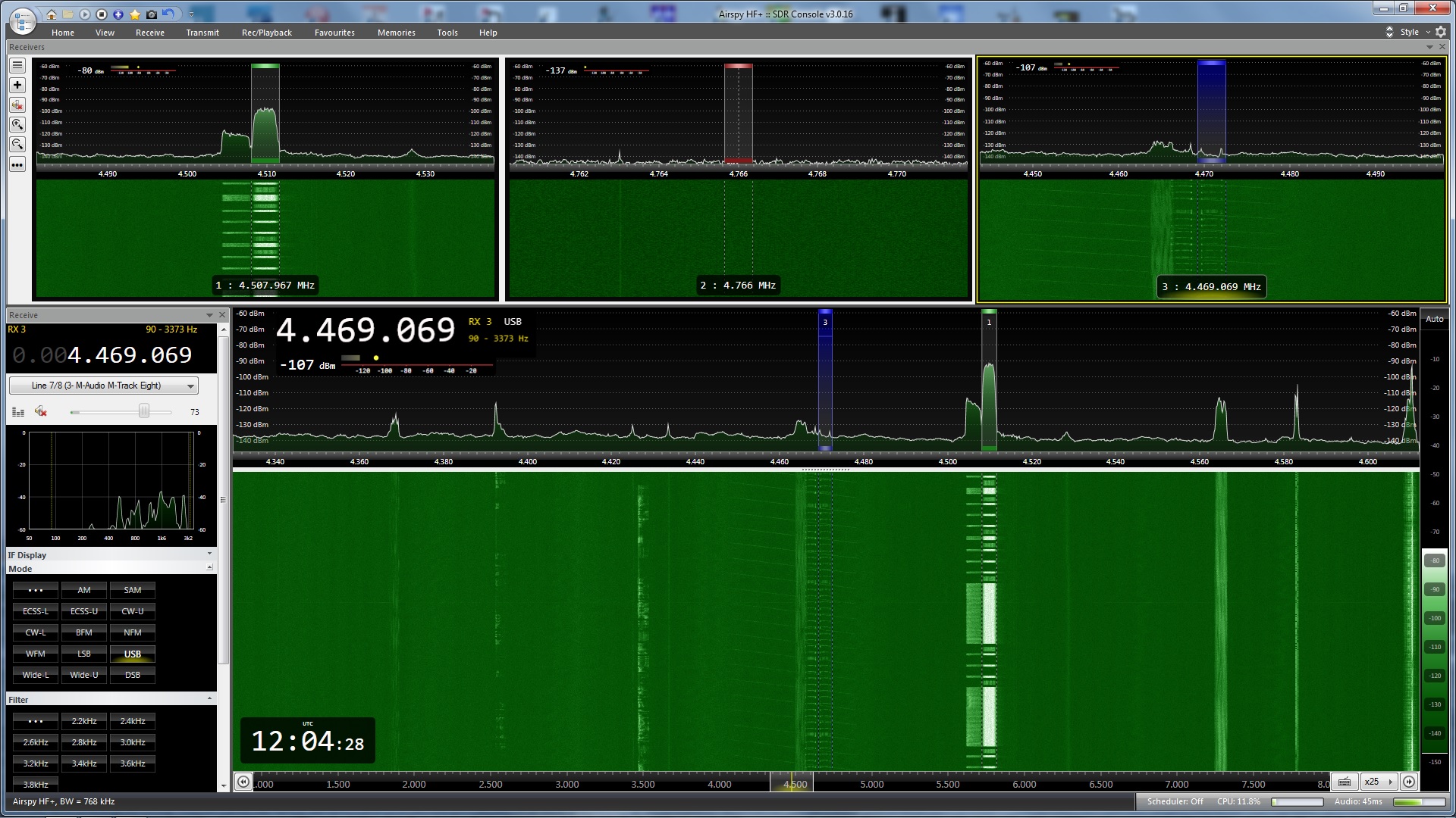
Let’s take a look at one the previous screenshots, but this time with annotations explaining a number of points.

Firstly, we need to look for the NCS. The easiest way to do this is to look at the NCS/Picket Designation and find transmissions that are a zero, combined with a Message Type that indicates it is a NCS IWM. Here, there is just one transmission and that emanates from Address ID 2_o – the long one that includes a data message.

We next need to find NCS/Picket Designation transmissions that still have a zero – therefore coming from the NCS – but that have a Message Type that show it to be a NCS IM. These are calls from the NCS to any PU’s that are on the network looking to see if they have any “traffic” or messages.

Because of this there should be numerous messages of this type, and if you notice none have an ID address of 2_o. However, all of these messages are actually coming from 2_o as the ID address shown in a NCS IM is that of the PU being called rather than who it is from.

Any reply messages from PU’s will show as a NCS IWM/PU Reply transmission, but importantly the NCS/PU designation will be a one – showing it isn’t the NCS. Here there is one data reply from 71_o. You’ll notice that in the “reflection” there isn’t any transmission, unlike the ones from 2_o.

Moreover, though not shown here as the messages were off screen and not captured in the screen grab, you can see that one of the PU’s sent another reply message. As I was able to look at the complete message history I was able to see that this was also from 71_o – and 2_o either replied to this or sent further data.

There are two fainter transmissions which were not captured by go2MONITOR. These were from a PU, and must have been 30_o as there are no transmissions at all in the sequence that are from this ID address.

We now have a quandry. Who was 30_o and who was 71_o?

Data is definitely being sent by 71_o so to me this is more likely to be a ship rather than a transmitter site – but – a strong TDoA signal pointing at St. Eval makes it look like 71_o is this location instead.

Now though, we need to think outside the box a bit and realise that I’m looking at two different sources of radio reception. The TDoA receivers I selected were nowhere near my location as I’d selected KiwiSDR’s that surrounded St. Eval. This meant the signal that was weak with me could have been strong with these, therefore giving the result above.

If I base the fact that I think USS Gridley is 2_o due to strength, then I must presume the same with 71_o and call this as Thor Heyerdahl as this is the second strongest signal. I can also say that having gone through the four and a half hours of Link-11 SLEW transmissions available that 30_o never sent a single data transmission – or rather, not one that was received by me.

Full four and a half hours of Link-11 SLEW as shown in the go2MONITOR results page. You can see other areas (in red) that I was decoding at the same same. By selecting an area in the results page you can access the data as decoded, saved into files. I could have further enhanced this and carried out a full audio recording for further analysis, but I didn’t on this occasion.

Here then is my conclusion:

  1. USS Gridley = 2_o and the NCS
  2. Thor Heyerdahl = 71_o
  3. St. Eval transmitter site = 30_o

Of course, we’ll never really know, but I hope this shows some of the extra things you can do with go2MONITOR and that it isn’t just a decoder. It really can add further interest to your radio monitoring if you’re an amateur; and if you’re a professional with a full plethora of gear, direction finders, receiver networks etc. then you really can start getting some interesting results in SIGINT gathering with this software – and highly likely be able to pinpoint exactly who was who in this scenario.

Now, how do I get some Direction Finders set up near me….Hmmmmmm??

Mini-Circuits and Stamps

mcl_top_banner

I recently received a global email from Mini-Circuits CEO, Harvey Kaylie, informing me of a Holiday Season discount. A copy of the email is below:

To our valued friends and customers,

To say thank you for making 2016 a successful year, we’re pleased to announce a special Holiday Season Discount:
All purchases of any quantity of Mini-Circuits catalog models ordered and shipped from our webstore on minicircuits.com from December 1st through December 31st will receive a 10% discount!

The discount will appear for items in your shopping cart on our webstore checkout page at the time of purchase. Please see our website for terms and conditions. This offer expires on December 31st, so don’t miss out!

From all the members of the Mini-Circuits family to all of you, our customers, we wish you a very happy, healthy holiday season!
Warm regards,

Harvey Kaylie
Founder and CEO
Mini-Circuits

I have checked with the UK supplier and I can confirm that the discount is available outside of the USA. Just order what you want as normal through the Mini-Circuits website.

Mini-Circuits components

Some of the components I have bought from Mini-Circuits this year

I bought some leads and components a few months ago and have been impressed with the quality of each item. The service from the UK supplier was excellent, especially as I had to change the order part way through the processing. All the components came from the USA, but the delay was minimal.

If you need some new components then get in there quick for the 10% discount.


Stamps of Radio Stations by Continents and Countries

At the end of November the SWLing blog had a post about collecting postage stamps with a connection to radio.

I’m by no means a proper stamp collector but the reason I found the blog of interest was because in August I had actually bought some First Day Covers and a Mint set of stamps commemorating 50 years of the BBC on Ascension Island. I had been stationed on Ascension in the 90’s whilst in the RAF and I spent quite a lot of my days off at English Bay beach which is right next to the transmitter site. Plenty of good memories.

The SWLing blog was about a Word document created by Lennart Weirell of Sweden. He has been able to collate a list of all the stamps that has a connection with Broadcast Radio and turn it into a twenty-four page document. It lists the 125 countries that have produced such stamps and the information includes date of issue, the Michael number, value (at issue) and name of the stamp. There are also tick boxes so that you can mark off whether you have these stamps in your collection. stamps

It doesn’t say this in the document but you can however go one step further than the tick boxes. If you have a scanner, just scan your stamps into a picture folder and then create a link to each relevant picture in the Word document. It’s as simple as highlighting the stamp name for example and then clicking on the Hyperlink button in the Insert tab group of Word (you can also use the Control-K shortcut). Just find the picture folder and the scanned image and link them up. As long as you don’t change the image location, each time you go to the Word document, clicking on the link will open it up.

The Word document is €4, but contact Lennart by email first so that he can send you a PayPal invoice. His email address and further information about the document is available on the image above.

The 50 years of the BBC stamps are available from the Ascension Island Post Office website.

First day cover

A scan of my First Day Cover “50 years of the BBC on Ascension Island” stamps

Propliner is back

Around 11 months ago I reported the sad end of Propliner magazine in my article “End of an era”.

I’m very pleased to say that due to requests to the editor that Propliner be kept in some form or other, he has decided to try out whether it could succeed in an annual format.

In his words “Within days of announcing my decision to suspend publication of Propliner as a quarterly journal, I became aware of the enormous sentiment surrounding the magazine, and that there were a large number of disappointed readers.”

He continues ” Having remained in touch with many of the regular contributors and having canvassed their opinions, I have decided to go ahead and publish a Propliner Annual in April 2016″.ProplinerAd

A brief outline of what is intended in the first (and hopefully not last annual) was also given – 96 pages full of features and photographs, as well as news on the past years events. Further information is on the advert to the right.

Amazingly, the annual is still going to be priced very reasonably indeed. For those in the UK, it is to be priced at £11 including delivery, with Europe at £13. The rest of the World is still only £15 for air mail delivery.

The target publication date is April 17th and orders can be placed at the Propliner website

PlaneBaseNG Update

Another bit of aviation news is a new update to the PlaneBaseNG database software. I ran a review of the database just over a year ago if you’d like to look back at what I wrote. Otherwise, head over to the website for more information, screenshots etc. PBlogo

If you’re looking for an aviation database then this is definitely the one to have.

Monitoring NATO “Joint Warrior” Exercises

***This blog now contains some information regarding the current Joint Warrior 151 exercise***

Most of November I was away on holiday to the USA which is why there was a lack of a blog last month. This month I’m going to release one of my articles that was published in the July edition of The Spectrum Monitor. tsmcover

As I’ve previously mentioned the magazine is available in digital format, and can be read on all electronic readers. A yearly subscription is $24, which is a bargain bearing in the mind the monthly content produced, totalling over 1200 pages a year.

This version is slightly different to the one published in the magazine as it contains some extra content.

Monitoring NATO “Joint Warrior” Exercises

Twice a year the UK hosts Exercise Joint Warrior(JW), planned by the Joint Tactical Exercise Planning Staff (JTEPS) based at Headquarters Northwood, about 5 miles north of Heathrow Airport. JTEPS is a joint organisation parented by both HQ Air Command & Navy Command (NC HQ).

The Official Mission of the Exercise is to:
Provide a joint, multi-threat environment in which UK, NATO and Allied units and their staffs may undertake collective training and pre-deployment training in tactical formations in preparation for employment in a Combined Joint Task Force

The number of participants is normally quite large, with up to 30 naval vessels, both surface and sub-surface, taking part. The number of aircraft taking part is substantially larger with sometimes up to 100 being involved. These include Maritime Patrol Aircraft(MPA), Fast Jets, Command and Control (C2), Intelligence Surveillance Target Acquisition and Reconnaissance (ISTAR), Transport, Air to Air Refuellers and Helicopters

As well as Air and Sea assets, there are Land based Air Defence units along with Paratroops, Army and Marines. The number of personnel involved is in the thousands.

JW normally involves forces from major European countries as well as the USA and Canada. Other countries such as New Zealand, Australia and Brazil have taken part in recent years.

This French Navy Aquitaine Class Destroyer "FS Aquitaine" (D650) is seen arriving at Her Majesty's Naval Base Clyde, also known as Faslane. The French are huge users of HF, in particular they use STANAG4258, RTTY and HF-ALE. The STANAG and RTTY is normally encrypted but you can sometimes get callsign information from the messages. They also use USB, especially the Transports, AWACS and Maritime Patrol Aircraft

This French Navy Aquitaine Class Destroyer “FS Aquitaine” (D650) is seen arriving at Her Majesty’s Naval Base Clyde, also known as Faslane. The French are huge users of HF, in particular they use STANAG4258, RTTY and HF-ALE. The STANAG and RTTY is normally encrypted but you can sometimes get callsign information from the messages. They also use USB, especially the Transports, AWACS and Maritime Patrol Aircraft

The exercises can cover the whole of the UK, but most of it takes place in Scotland and its surrounding waters. There are certain areas in other parts of the UK that are used, for example the Spadeadam Electronic Warfare Training Range (West of Newcastle, England) and Fast Jet Areas over the North Sea (for Air to Air combat). But it is the limited population of the North West of Scotland, along with quiet air and sea traffic, plus access to both deep and shallow waters, which allows almost total freedom for the participants. There are also numerous weapons ranges some of which include areas designed specifically for Naval Gun Support (NGS) and Close Air Support (CAS) – Cape Wrath on the North Western tip being the main one.

Joint Warrior 141 (JW141) took place between the 31st of March and the 11th of April, 2014. The week prior to the main start of the exercise there was a general build-up of forces as the scenario heads to conflict between fictional countries, starting with Amphibious Forces congregating at West Freugh and Luce Bay off South West Scotland.

"SSN Missouri", a USN Virginia Class SSN, leaving Faslane in 2013.

“SSN Missouri”, a USN Virginia Class SSN, leaving Faslane in 2013.

Meanwhile, the main naval forces from the different participating countries generally arrive at Naval Base Clyde, more commonly known as Faslane. The base is close to Glasgow, and is the home of to the majority of the UK Submarine Fleet, including Vanguard Class SSBNs and Astute Class SSN hunter-killer submarines. It is also the home of the mine countermeasures fleet. Faslane gets regular visitors from various Naval forces throughout the year, a not too uncommon site being USN Virginia Class SSNs that pass through for supplies and crew rest.

JW141 hosted the following countries sea and air elements:

The Netherlands and Belgium also provided Marine forces, as well as the Netherlands and USA providing Forward Air Controllers (FAC).

The UK of course provided the largest amount of participants with numerous ground, Paratroop and Marine regiments, Air Defence and FACs taking part, along with sea and air elements consisting of:

I’m pretty sure there would have been at least one UK Submarine involved though I do not know the details of this. The Astute Class are still in their infancy and so would have been ideally chosen to take part.

Despite my previous statement that it is quiet in Scotland when it comes to sea and air traffic, it isn’t desolate. There is still a large amount of flights into the major cities of Scotland, it is just it is quieter than in Southern England . There are numerous daily warnings sent out to civil aircrews about possible military activity and this works in the other direction too, with the military crews getting briefings on airways and areas to avoid.

Sea warnings aren’t left out either, in particular for the large fishing industry that exists off the West coast of Scotland. For this, JTEPS produces a document that is published on the Government website that provides information on Submarine, Minewarfare, live firing and denial of GPS training for the exercise. This can be a useful document should you be interested in following what is happening during the exercise as it tends to have a program of events and maps.

***I have updated the page to show the document for the current JW151 exercise and it can be found here. There are also daily SUBFACT and GUNFACTS broadcast as part of the NAVTEX warnings

Radio Communications

What JW does bring with all this action is radio communications. In fact, one of the main aims of the exercise is to establish common procedures between forces that are likely to work together for real in a combat area.

All types of communication methods are used, including the old fashioned “flag” and “flashlight Morse code” between ships. In the majority though, it is of course radio that is used to its fullest. And, it is the full spectrum that is used from VLF all the way up to SATCOM, most of which is easily received by monitors around the UK and further when it’s HF that is being used.

As well as voice comms, data takes a large part, especially RTTY, Link 11, Link 16 and STANAG4285. All of this is normally encrypted but if there is a non NATO country taking part then sometimes data is sent in the clear, especially RTTY.

Because of the large expanse of operating areas, HF is used extensively. Over the last few years I’ve built up a record of frequencies used that have been monitored by myself and others also interested in the JW exercises.

A Lockheed Orion CP-140 of the Royal Canadian Air Force, 140116, lines up to depart Lossiemouth during an intense sandstorm in 2013. Just visible in the background is the parking area for the Maritime Patrol Aircraft (MPAs) that take part in Joint Warrior. The usual mix includes USN P-3 and RCAF CP-140 Orions, but has included French, German, Norwegian and Brazilian Navy MPAs in recent years

A Lockheed Orion CP-140 of the Royal Canadian Air Force, 140116, lines up to depart Lossiemouth during an intense sandstorm in 2013. Just visible in the background is the parking area for the Maritime Patrol Aircraft (MPAs) that take part in Joint Warrior. The usual mix includes USN P-3 and RCAF CP-140 Orions, but has included French, German, Norwegian and Brazilian Navy MPAs in recent years

The Maritime Patrol Aircraft normally operate out of RAF Lossiemouth and arrive a few days before the exercise begins. Once StartEx has been announced there is at least one MPA airborne at any one time until the exercise ends, quite often though there are two airborne. Mission lengths are around 6 hours including transits and they consist of Anti-Surface Warfare (ASuW) and Anti-Submarine Warfare (ASW). The aircraft are designated a trigraph callsign such as A8X as allocated to the USN P8A of VP-5 on the 2nd of April, and these are changed daily. One thing of note with the NATO MPA element of the exercise is that the aircraft are not allocated their callsigns by the exercise staff but from NATO itself, as they are on call to deal with any real-world scenario that may take place. Should there be any non-NATO MPAs in the exercise then these are allocated their callsigns as normal by JTEPS.

When the aircraft get airborne they normally call Northwood, callsign MKL, on HF with a departure message. This is followed by an on-station message and then hourly sitreps until off-station and then landing. They would also call for any information or if they themselves have something to pass such as enemy sightings. The primary frequency used on HF is 6697kHz. As well as using HF the MPAs will communicate on UHF with any vessels in their operating area, though this well out of range of my location so I don’t normally hear this.

RTTY (or RATT) is the primary method of passing the information, though this quite often seems to fail. It is quite amusing sometimes listening to an MPA set up a RTTY message by voice with MKL, which then fails repeatedly, sometimes taking 15 to 20 minutes of attempts. They then give up and send by voice a 30 second message – I sometimes wonder why they bother, especially when it’s something as basic as a departure message.

I normally set up my Icom IC-R8500 and Winradio Excalibur right at the beginning of the exercise to monitor the HF frequencies, in particular the MKL primary 6697 kHz. Along with this I ensure my Bearcat UBC800XLT is up to date with all the correct VHF/UHF frequencies, and that my Bearcat UBC3500XLT mirrors it for when I’m mobile

Talking of going mobile, my usual routine is to head to the Faslane area to catch the arriving and departing ships. Normally, the ships will arrive on the Thursday and Friday before the start of the full exercise. Due to the large amount of ships involved they are given arrival slot times, much the same as aircraft do at airports. This is so that the local Harbour masters, Police escorts, Tugs and Pilots are not stretched to the limit with everything arriving at once. The ships use the standard Marine VHF Channels to communicate with the Pilots etc (Channels 12, 14, 16 and 73). This is usually quite interesting to listen to, in particular this year with USN participation – for instance USS Cole was very twitchy about pleasure craft in the area, even asking the Police escort to intercept a suspicious vessel heading straight for them. The calm response of “Errrr, that’s your Tug and Pilot” was quite funny. On the Sunday, the reverse takes place with all the ships leaving, this time slightly more grouped in small flotillas.

Arleigh Burke class Destroyer USS Ross (DDG 71) about to pass RFA Lyme Bay (L3007) of the UK Royal Fleet Auxiliary

Arleigh Burke class Destroyer USS Ross (DDG 71) about to pass RFA Lyme Bay (L3007) of the UK Royal Fleet Auxiliary

Over the weekend, RFA Lyme Bay and RFA Orangeleaf had anchored a few miles short of Faslane at an area near to Cloch Lighthouse (where I based myself). I was able to receive both these ships on UHF frequencies though I was unable to clearly tie-up the callsigns used by the ships. Just before 0700z, numerous coded messages were sent between the callsigns 8DE and 7GO. These continued until 0800z when 8DE calls “Anchors away”. There was the sound of horns across the bay and RFA Lyme Bay moves off, turning a tight 180 degrees to head south. RFA Orangeleaf follows behind. From this I concluded that 8DE was probably Lyme Bay.

When I’m waiting for things to happen, and scanning with the UBC3500XLT, I’m also using the Close-Call facility of the radio for the UHF band to see if I catch anything else. This time it didn’t work, but another monitor in Northern Ireland was a lot luckier and was able to add a few frequencies to the growing list:

There were plenty of calls on these frequencies, but the usual line of sight problem arises with UHF and the ships would quickly disappear out of my range. But it didn’t matter as HF is used extensively because of this very problem for the ships themselves.

Monitoring from the Shack

With the Icom on 6697 kHz and the UBC800XLT scanning the hundreds of VHF/UHF frequencies, I’d use the Excalibur to search through for the ships HF communications. Like the VHF/UHF ones, there are frequencies that are used every year and one’s that aren’t. But once you’ve found the regular ones you can pretty well catch most of the action. Along with a small group of others that also monitor JW we were able to build up a good picture of what was going on.

It became clear quite quickly that 4706 kHz was being used for Ship Air Defence calls. Over the two weeks this task would be carried out by various units, and by all military methods – Land, Sea and Air. The Land element would be carried out by the RAF Air Defence Unit, based at RAF Boulmer (usual callsign HOTSPUR). The Air element would be from a E3 AWACS (though not that often) and the Sea element would be carried out by a ship. By the callsigns used it sounds like the task is split into three during a 24 hour period, with maybe Boulmer doing 2 slots and a ship the other; or whatever the aim of that days scenarios that have been planned by JTEPS.

The calls would look something like this taken from my logs:
(1132z)
J0T this is G1T
New friendly ML500
Position MKQN0105
Hdg 287
New friendly ML500

(1133z)
Update friendly ML500
Pos MKPN5606
Hdg 287
Spd 166kts
Strength1
C height 19
Update friendly ML500

This is decoded as:
ML500 = allocated track ident by radar operator
MKQN0105 = grid reference
Hdg 287 = Heading 287 degrees
Spd 166kts = speed of track
Strength 1 = number of aircraft in formation
C height 19 = Mode-C radar height

These calls are made very quickly, every 30 seconds to a minute, and actually get quite hard to write down. The training carried out from these calls is very important and not only assist the radar operators but also things like the defence systems on board the ships.

Cobham Aviation Falcon 20 G-FRAW taxies for take-off from RAF Lossiemouth during Joint Warrior 12-2 in 2012. The photo clearly shows all the additional pods these aircraft carry for replicating different aircraft, radars and weaponry

Cobham Aviation Falcon 20 G-FRAW taxies for take-off from RAF Lossiemouth during Joint Warrior 12-2 in 2012. The photo clearly shows all the additional pods these aircraft carry for replicating different aircraft, radars and weaponry

The exercise uses the Civil fleet of Falcon 20 aircraft of Cobham Aviation Services to replicate different aircraft. To do this they use towed targets that can be programmed to have the Radar Cross Section of aircraft such as Sukhoi Su-27or Su-35 Flankers to give the radar operators a true feel of what they would possibly see for real. The pods also replicate missiles as fired by the “enemy” aircraft and can be programmed as such, a “favourite” being Exocet as these have been used in anger against Royal Navy ships, sinking a few in the Falklands Conflict in the early 80’s. The Falcon 20’s can fly very low over the sea up to 300KIAS, and believe me they fly low, I flew in one year’s ago. Other equipment carried can give immediate information of simulated hits or misses by the ships Air Defence weapons, much like ACMI pods (Aircraft Combat Manoeuvring Instrumentation) carried by aircraft.

Sometimes the Falcons also fly with Royal Navy Hawk fast jets, operated by 736 Naval Air Squadron. 736NAS used to be known as FRADU (Fleet Requirements and Aircraft Direction Unit) and the task of these Hawks is to simulate low flying missiles against ships. As the Hawks can fly faster than the Falcons this gives a better simulation to the ship’s crew to help them learn how to combat the threat, or at least reduce the possible damage caused should the missile get through. The Hawks can also carry out the same task as the Falcon 20s replicating enemy aircraft.

The Falcon 20s can also carry out other tasks such as Electronic Warfare by jamming the radars and radios and using chaff and flares. They are very capable aircraft and used continually by the UK, not just in exercises such as Joint Warrior.

By far, the best Maritime Air Defence platform currently at sea is the Daring Class Type 45 Destroyer of the Royal Navy. In JW141 it was HMS Dragon of this class that took part. The Daring class destroyers are fitted with a Marconi Type 1046 Air/Surface search radar which functions in the D-band; and a Surveillance/Fire Control E/F-band Type 1045 (Sampson) Multifunction radar made by BAe Systems. These radars combined can give a 400km,/360° coverage, linking in to the Principle Anti-Air Missile System (PAAMS) which provides target cueing, anti-jamming, radar de-clutter and other functions necessary to protect itself and any other ships in the fleet. For protection the primary weapon is a Vertical Launch System (VLS) capable of holding 48 missiles in single missile cells. These hold either Aster15 or Aster30 S/A missiles with ranges of 15nm and 30nm respectively, with Aster30 reported to have a range of up 65nm. The VLS is capable of having a mix mode, where any combination of the two missiles can be held, the usual mix being 32 Aster 30s and 16 Aster15s. Future developments of the Aster30 include an anti-Ballistic Missile version with a range far exceeding that currently available, with reports of it having a range of 540nm, with a further version exceeding 1200nm.

© 2014 Tony Roper.No usage permitted without authors permission

Göteborg Class Corvette Sundsvall (K24) of the Swedish Navy in a Joint Warrior exercise from April 2013. Every exercise has different participants from different countries, which allows for greater training and learning of techniques used by the differing Navies of the World

It would take pages to go through everything you can hear on HF during JW. It’s a 24/7 activity as the exercise runs day and night, 7 days a week including weekends. You can normally hear the Gunnery ranges at Cape Wrath as ships take it in turns to simulate attacking shoreline targets, normally given instructions by FACs. There’s general radio chat with resupplies, tasking of ship helicopters, and as previously mentioned, the setting up of RTTY and STANAG4285. Most of the general calls were on 4915.5 kHz which seemed to be the Primary Ship HF frequency. Plenty of callsigns were heard every day, though in the majority they couldn’t be tied up as intended.

HF frequencies used over the years that have been logged by myself and others:

Air to Air

© 2014 Tony Roper.No usage permitted without authors permission

Royal Air Force Tornado ZA404/013 in full afterburner as it departs RAF Lossiemouth in April 2013 on a Joint Warrior mission. Being this close to the runway is very noisy and very hot. Within 6 months, this Tornado had been transferred to RAF Leeming and scrapped, being used for spare parts for the remaining fleet of Tornados

The Air element of the exercise takes place for most of the two weeks with a multitude of tasks being carried out by the Fighters, Transports, Tankers and electronic warfare aircraft. Again, to go through the full amount would take pages of information but I’m sure you can imagine how busy the airwaves can be with such a large amount of aircraft taking part.

In the majority, the Fighters use Tactical Air Direction (TAD) frequencies (most people incorrectly call them Tactical Air Designator frequencies). These are “real time” frequencies used by the Air Defence Network in the UK and there are hundreds of them. The actual frequency is never said on the air with the TAD number (channel number) passed instead – TAD156 for instance. To confuse things even more, in JW the TADS are given other codenames, normally colours (as are the HF frequencies in fact) and these are said over the air too. Of course, if you have the TAD frequencies this isn’t a problem as you can tie the colour up. As it is, there isn’t a definitive list of frequencies officially available, though some are known.

As you can imagine, the chat on the frequencies is busy as fighters intercept others fighters, or transports and such like. It’s interesting listening and hasn’t changed much from when I was in the RAF. Though, I’ve got to say it isn’t as busy as it used to be, mainly down to target datalinking between aircraft. The datalinking means that less information is passed over the radios either between aircraft in a formation, or from E3 AWACS for instance. Data is also transmitted from the ground from the Air Defence networks or mobile forces.

The Hercules transports were kept busy most of the exercise with plenty of paradrops, both human and freight. And there were plenty of Helicopters around from ships, as well as RAF and Army elements. Most of this is carried out on common inter-squadron frequencies, and those of the main RAF Area Control based at Swanwick in Hampshire (Southern England, and also home to the Civil London Area Control Centre).

This year the exercise ended with an “Apocalypse Now” scenario with a mass Helicopter and Hercules assault on a disused airfield, RAF Kinloss. This is far out of my range being about 240 miles away so I wasn’t able to monitor it, but I did catch the Helicopters travelling back and forth from there to West Freugh where a mobile base had been established, West Freugh being about 40 miles to the south of my QTH.

Overall, the exercise normally brings a good build up in radio communications for UK listeners, especially HF. But unfortunately, HF isn’t that popular within the Military listeners of the UK where the majority listen to VHF/UHF frequencies. The funny thing is, they’re probably missing the vast part of the exercise.

Three Tornados of the RAF carry out final checks lined up on the runway during Joint Warrior 12-2 in October 2012. Tornados operate with two crew, Pilot and Navigator/Weapons Officer, and have been in full service in the RAF since 1982 but are now in their final years. They have served the RAF well over this time, taking part in all combat Operations since their initial introduction into service, including Operation Desert Storm where they flew as low as 50 feet at over 500mph (something they do every day over Scotland). Their crews are probably the best Low-Level combat pilots in the World

Three Tornados of the RAF carry out final checks lined up on the runway during Joint Warrior 12-2 in October 2012. Tornados operate with two crew, Pilot and Navigator/Weapons Officer, and have been in full service in the RAF since 1982 but are now in their final years. They have served the RAF well over this time, taking part in all combat Operations since their initial introduction into service, including Operation Desert Storm where they flew as low as 50 feet at over 500mph (something they do every day over Scotland). Their crews are probably the best Low-Level combat pilots in the World