Unconfirmed reports of “drone attack” on Engels Airbase, Saratov on 5 December 2022
Satellite imagery not yet available for 5 December 2022
4 December imagery available from Planet for potential comparison when 5 December becomes available
Various reports appeared on Social media regarding a potential Ukrainian forces strike on Engels Airbase, outside Saratov in Russia.
#war Russian near-military telegram channels report an explosion at the strategic bomber Air base in the Saratov region. We are talking about two damaged bombers. There is no official confirmation from the🇷🇺MoD.
Engels is home to the 121st Guards Heavy Bomber Aviation Regiment flying Tu-95MS and Tu-160 strategic bombers. The base has been used extensively during the Ukrainian War campaign.
Whether this was an attack or not – the range to Engels from Ukraine is over 500km, probably closer to 600km for any of the Ukrainian positions – any damages to aircraft could be a hindrance to the Russian operations.
However, in 4 December 2022 imagery, there is a significant number of Tu-95s present – 18 in total. The reported damages (or loss?) to two Tu-95’s wouldn’t affect that much. With only 5 Tu-160’s present – out of a fleet of 17 – any loss to these airframes would be a little worse for Russia. But, there’s plenty of replacements available.
By comparing the image below, with that available on Jane’s from 17 October 2022, very little has changed. It is hard to assess Tu-95 and Tu-160 activity between the two dates. At least one Tu-160 (in the maintenance area) appears to have not moved.
Note: The imagery doesn’t take in the southern part of the taxiway system where aircraft have also been placed previously. I suspect there are some there but the numbers above do not take these into account as I won’t guess. The image is annotated with IL-76’s though these could also be IL-78’s.
I make no apologies for the watermarks after recent imagery theft.
Update – 5/12/22 1550 UTC
Looking at Sentinel imagery for 5 December, there does not appear to be any evidence of an explosion at the airfield. Certainly not of an aircraft. Sentinel is low resolution of course, so high resolution imagery is needed to confirm still.
The potential railhead source of the explosion still can’t be ruled out as there is a high glowing area there. This does appear to be here in earlier passes however, and could just be a consistent heat source or sun reflection.
The imagery also shows 5 aircraft parked on the southern taxiway/runway – possibly two IL-78’s and three Tu-95’s.
The attack on the Kerch bridge has been an interesting source of discussion as to what the true cause of the explosion was.
Experts in the field of explosives, forensics and analysis have come to different conclusions on the subject. Many have said it could be any of the options and they just can’t say which it is.
And, of course, it has brought out the amateur “experts”.
I place myself somewhere between the two. I’m certainly not an expert in explosives or forensics when it comes to finding the source of an explosion/IED, but I like to think I’m pretty good at analysis – though not infallible. No one is!
This report is a discussion of ideas and thoughts. It isn’t a “It was truck” or “it was a boat” – it is a showing of evidence that I have found. Others have done the same. I will say now – I am ruling out a SOF planted devices or missile strike, and I won’t even cover these here.
However, I have found through watching the videos of the explosion some possible evidence that doesn’t seem to have been picked up elsewhere. The challenge was to find further evidence – this shows some.
The most popular conclusion for the explosion is the truck bomb. Quite handily, the Russian government also stated this was the source. They came up with the driver’s name, a company involved, cargo – even the route he took for the days preceding the explosion, and the strange action of taking 6 hours to drive along a road that should have taken less than an hour.
We all believe everything Russia says don’t we? In this case, it seems we do!
The Russians failed to say that the 6 hour extension of the journey was probably because the driver was asleep in a rest area somewhere. Russian “investigators” came up with Makhir Yusubov from Kazan in Tatarstan – but living in Krasnodar, south Russia – as the driver, and a story of fake companies. The family are being investigated.
An x-ray of the truck has been produced that shows the “explosive cargo” in the trailer – a trailer that doesn’t match that of the type that was used! There’s an axle missing and the underside safety rails are different! Clearly a fake.
This x-ray imagery was then said to be of another truck and the “cargo” was exchanged between the trailers – interesting as really all that needed to be carried out here was an exchange of the trucks themselves, and a change of number plates on the trailer. Why take the risk of moving the cargo from one trailer to another?
Parts of the destroyed truck are available in photos taken at the bridge, whilst eight men have now been arrested – five Russians and three others (Armenian and Ukrainian) – connected with the bombing.
The FSB have carried out a very swift investigation that’s for sure. Too swift maybe?
Why a truck bomb?
This is the first question I asked myself when I heard about it. The truck bomb certainly looks to be the cause of the explosion from the current evidence. Here’s my list of oddities I noted in my hypothetical blog on the day:
1 – There is quite good security for vehicles to get through to pass across the bridge. The lorry in question doesn’t appear to have been that well searched but it was stopped.
2 – If it was the lorry, why didn’t it drive slower, or even stop?
3 – If it had stopped, there is no security in that area. The driver could have bailed out of the vehicle and set it off remotely, or by a short timer – therefore surviving the attack.
4 – Why was it in the “slow” lane? For best results it would have been on the outer lane, nearer the southbound side; and the rail bridge. Stopping would’ve been even more effective.
These still stand. Point 1 was risky. It could have failed before the truck even got to the bridge.
Moreover, there’s now more to add to that list.
5 – Why detonate the bomb at that location? Surely the arch area was a better target than at the beginning of the up slope to it.
6 – How did the bomb detonate?
If it was by the driver who had instructions, then point 5 surely counts here. As does points 2, 3 and 4.
Maybe it was a timed detonation? See point 9.
If it was by remote GPS triggering then – as the Lat/Long of the bridge can be obtained from Google Earth very easily – either the accuracy of the GPS was very poor, or the position was entered incorrectly! Most GPS devices available are accurate to a couple of metres so this does look to be either an incorrect entry or – more likely – not the trigger source.
7 – Leading from point 6 then, was there a following vehicle that remote controlled the detonation from afar and the driver didn’t know what he was carrying?
Again, this needs Point 1 to be bypassed. And by two vehicles. There was no way of telling how long it would take the two vehicles to get through security – and whether it would all happen in time for the following vehicle to be in the right place. It is extremely risky.
One caveat here though – if the Russians were involved and knew the following vehicle would get through security – or they used the bridge CCTV to see where the truck was.
8 – Was the train a planned part of the attack?
This could have been a lucky break. Why? Because the driver took a 6 hour break. According to the paperwork Russia provided, he should have crossed the bridge earlier than this. If it was part of the plan then timing needed to be perfect. It was certainly another risk that may not have worked out – it still might not have.
9 – This leads to – was the bridge the actual target?
Going back to point 6 and the timed trigger along with the fact that the driver rested for 6 hours – if it was a timer then the truck should have been elsewhere at the time of the explosion and not on the bridge. A new can of worms.
10 – The truck and driver originated their journey in Russia. This needed to be a very well planned and executed job to carry out to success. With the arrest of the eight men, five of them being identified as Russian could have made this easier.
It will be interesting to hear what their backgrounds are. It’s certainly a mixed bunch, with in theory, only the Ukrainians being the “enemy of Russia”. If all this is a fake story to try and conceal something else, then I wonder whether the Russians are prisoners and refused to fight or whatever. There’s plenty of poor fodder the Russians could use for this.
So, the truck bomb theory certainly throws up a lot of problems with the actual mission, a lot of uncertainties – and a lot of luck.
Analysis time
One amateur analyst, Oliver Alexander, has carried out near continual watch on this and insists that it was a truck bomb and has provided “conclusive evidence” for this.
All current evidence points to the most likely and obvious cause, with nothing currently pointing against it. For some reason everyone has to make up a million more complicated theories with a large amount of holes solely because they want something else to have happened – he said to me in a Tweet.
To be a true analyst in this game you need to look at all theories – no matter how complicated they may appear. Every theory needs to be eliminated.
He has carried out some great work, but most of it has been on the truck theory.
He asked for other evidence to point otherwise. So here’s some to look at.
This has taken a couple of days to go through. You see, despite being an “old man” – as he called me (51 btw) – my experience in working in this field has taught me to take my time and go through things systematically. This is the benefit of being “old” and having had years of experience – unlike those with the absolute desperate need to get thousands of followers and likes on Twitter, some kofi cash and their name in a newspaper!
Whilst much evidence does point to it being a truck bomb there are still things that don’t quite add up. It’s not just me saying this – there’s plenty of far more qualified people than me that can’t decide.
So let’s talk about the “boat under the bridge” theory. After the early video footage came out I created my previous blog based on this. It was a hypothetical “story” based on the very early comments of a boat being visible.
However, it was reasonably clear that it wasn’t a boat that was visible under the bridge, but a wave. What causes the wave is the question.
All we really have to use is the footage from this CCTV video to see the water flow of the strait. I couldn’t find any others. The image above highlights “the wave”. As you can see, under the rail bridge there is another wave passing through.
Satellite imagery doesn’t really show that much either as the bridge is new and there’s not much historical imagery to analyse. Mainly though, it looks not that rough in the historic satellite imagery that is available. However, this can’t be used in evidence to show normal water conditions. Living in an area that is much the same, I can tell you it differs every day.
There is likely to be turbulent waters as the two sea areas meet, along with the addition of those caused by the bridge support pillars. An image later in this report shows the choppiness of the area a few days after the attack.
This surge wave could have been caused by a number of things.
1 – A boat. Yep, it could have been. Either ramming into the bridge off screen, or manoeuvring/stopping adjacent to the bridge – especially so if it was coming in at speed.
2 – Just a random, choppy, wave.
3 – Caused by the extra circular bridge extension that is located in this gap that comes off the side of the bridge.
None of these can be proven without seeing more everyday footage – especially for point 3 which is the only permanent item there.
Therefore, the boat could be a possibility, but less so than the truck – according to evidence so far shown.
Let’s check the other CCTV footage to see what we can spot.
Taken from the CCTV camera behind the explosion you can see plenty of debris raining down. I’ve circled a few to highlight specific points.
To the left, this is debris hitting the rail support pillar. This pillar is nearer to the camera than the truck just visible going away from us, which was approximately 170 metres in trail of the truck that “exploded”. The rail support pillar is about another five metres further away.
What’s interesting here is the way the glowing debris travels. The bottom left circled is a large piece hitting the base and behind the pillar. This means the debris has travelled 175 metres in a straight line to get to this point. Plus the vertical movement.
The wind looks to be at about 60 to 80 degrees, speed unknown. In the image above you can clearly see that the wind is blowing in this direction – right to left.
The image below shows the rough direction the debris has travelled to ignite the train with the red arrows, whilst the blue arrow shows the approximate direction of the wind later on in the day. There is damage to the rail bridge to the south of the train but this is very little in comparison to that caused by the burning fuel cars.
Weather information from Kerch airfield approximately 11 kilometres away has been provided as an example of the wind at the time of the explosion at the bridge. Whether any time zone conversions was put in to this is unknown as for example if I look at the same data for Kerch airfield right now I get a 1200 time when it is 1400 at Kerch. Regardless of this, it was pretty much the same at the airfield for the time periods before.
However, as the day progresses the wind shifts around, as the wind does. At one stage it is 080 degrees – a twenty degree difference to a couple of hours earlier. And this is an interesting aspect that needs to be looked at.
The wind at the bridge could have been completely different to the airfield despite the relatively closeness of the two points. This can be proven at airports where two that are close to each other with nearly the same runway direction configurations can be on completely different ends for arrivals and departures because the wind is completely different at the two locations.
However, from the under rail bridge CCTV, the steam and smoke is clearly at right angles to the bridge so it looks like it was roughly the same here.
Image courtesy of Maxar
Back to the explosion image, the highlighted area to the right of the breaking truck is in front of the circular extension to the side of the bridge. Debris is coming down around the car and truck in that area too. All of this debris is coming from quite a distance to the right. We know that the truck and car didn’t go past the circular area or they’d have fallen down at the split in the road 15 metres before.
For this debris to arrive at this point, from the right, from the approximate position of the truck, it needed to have travelled at least 220 metres. Not only that, it needed to have gone vertical and fought against the wind to get to the point to start coming back down again.
This takes quite some effort, even for this size of explosion, for what has been stated to be AN/FO (ammonium nitrate/fuel oil) with powdered aluminium added as the used explosives. All of this is very lightweight. Bits of the truck would have gone that way for sure and I expected larger pieces to have been seen coming from the truck area rather than all this “glitter”. Despite the wind I would have expected to see debris coming towards the CCTV camera, directly over the vehicles and down the road. This doesn’t appear to happen.
I would also have expected the greater amount of debris and “glitter” to be directly behind the truck and more concentrated to the left. It is denser to the right of the truck.
From what I can ascertain, the CCTV camera is on the overhead gantry at Tuzla Island, about 1.2 km away and heavily zoomed in. It is possibly over the southbound lane, but could equally be over the central reservation.
Playing the video in slow motion, frame by frame shows much of the smoke and debris coming from right to left. This is more obvious if you play it backwards. In fact, a lot of it comes from off screen!
Explosions tend to go up, unless they’re directed, and around in a circular direction. Yet this doesn’t appear to happen if the position of the truck is taken into account at the time of the explosion. As the initial flare clears there is no residual debris above the trucks position, hardly any to the left – but most is to the right, travelling left. This would imply that the explosion happened to the right of the bridge.
We’ve all seen enough “tank turrets into space” videos to see that things go up from an explosion.
In the footage from the CCTV from under the rail bridge a lot of the debris comes from high right and reasonably close to the camera itself.
Below is just over one second after the explosion. Even taking into account some zooming and the debris is falling halfway between the camera and the next pillar, this is 120 metres behind the position of the truck. The majority should be coming straight at the camera, not right to left – or there’d at least be a mix of debris – at the camera first and then right to left as the debris thrown south then starts travelling west. Nothing ever appears to come at the camera as would be expected.
About four seconds later and it is dying off, but debris is still falling right to left between the next two pillars. Note the amount of debris falling onto the road from far off to the right. These embers will be hot enough to melt the tarmac creating little pits.
A few seconds later, the southbound road catches fire for a brief period. This is one of the biggest causes for the blackened area that is left here. The white smoke under the bridge is in fact steam from the hot road section that has collapsed suddenly being super-cooled by the water.
Shortly after, the water gets extremely turbulent as shown below. Many people have highlighted this but it has been dismissed as just the normal conditions. It isn’t, it is caused by the blast and collapsing bridge – it is much rougher than before the blast.
Moreover, commentary says that this can be dismissed as the rough water is “is also under the wrong part of the bridge.” It’s under the wrong part of the bridge why? Because it isn’t only under the arch that took the blast from above?
This is confirmation bias because the belief is that the truck was the source of the explosion – and nothing else.
The end of the clip gives us a good close up of the damage. This in itself hopefully clears the myth that everything will get bent away from a blast. This doesn’t happen, as the nearest upright light pole shows – it would be bent towards the camera.
The retaliatory attacks on Kiev highlighted that things above an explosion can be damaged on the top.
The glass bridge example has shrapnel and burnt areas caused from debris landing from an explosion below and blackening the path. There was no real fireball here however, so it wasn’t as bad as at the Kerch bridge.
One can see the weirdness of explosions though. Below is the glass bridge taken from a video. The explosion took place about 30 metres directly below this point. The glass panel to the right is damaged by debris but didn’t shatter – the one in the middle has been destroyed – but the one to the left is intact but has been warped by the heat and twisting of the metal frame to bend towards the explosion.
Despite all this, up until below, going through the evidence I was still of the mind that it was likely to be the truck – despite what some people may think because I questioned the way they said things on Twitter.
More evidence?
Back to the gantry CCTV at Kerch and we see some evidence that I think has been missed elsewhere.
For the next sequence of images I’ve marked the position of the truck (red dot) and circular extension (blue dot) just before the explosion. I’ve also created a pseudo crash barrier that extends past the circular extension point. There is slight movement in the positions due to camera shake, but for the examples below it is marginal and makes no difference to the analysis.
This video is good because it hasn’t been cropped in close, therefore more of the area above and around the truck is visible.
Because many reTweeters etc. have zoomed into the truck they’ve missed things happening elsewhere. Below I have highlighted an area that has solid debris going vertical, right to left. Had it come from the truck area it would be going left to right or straight up from the red dot.
By moving the video frame by frame I was able to plot a couple of them. The first is below. The debris travels up and right to left. If you imagine this line extended down it has come from a long way right of the circular extension – in other words from the river.
Here’s another. Again, the imaginary line would take it down to the river. There’s several of these that all show the same trajectory. One thing is for sure – these bits of large debris have not come from the truck! That is unless it has miraculously gone sideways and down, before propelling itself back up and in the opposite direction!
Play the video yourself and look in this area. Stop it and control the playback yourself. Play it backwards and forwards. You’ll see this debris.
So where has it come from?
The boat theory has always been that it was positioned under the bridge.
This created the “It can’t be a boat, there’s no damage under the bridge” and “it is definitely damage caused from an explosion above the surface” comments.
Confirmation bias has kicked in. The belief that a boat was under the bridge made people look for the damage under the bridge rather than looking wider – and at the full picture. They have seen what they wanted to see to confirm their beliefs.
Now, their beliefs may still be correct, but there’s evidence in those pictures above – taken from the very same video they say PROVES it was an explosion from the truck – that could show otherwise.
What if the boat was actually to the side of the bridge rather than under it? What if it went off early? What if it was GPS triggered and something went wrong with that? What if the person controlling the boat activated it early to get the train too?
Sound familiar?? All possibilities that have been given to the truck theory, but completely overlooked for others.
A boat gives a further option the truck doesn’t. What if the boat was being controlled remotely and something failed with that, or the steering went – anything that could go wrong with it that meant it was detonated early or in the wrong position.
Yes, there’s bits of truck being found, but if the explosion was close enough it would have probably been practically destroyed in the process anyway. It certainly would have been pushed to the side, into crash barriers making them collapse and break up – a theory used to prove the bomb went off next to the barrier – before disappearing into the water. Bits of it would have turned up in more places than one location – regardless.
One final set of pictures.
This first one is supposed to prove a 2000 kg bomb in a truck detonated at this position due to the slight dip in the southbound road. If that had happened I’m pretty sure it would have been in a substantially worse condition than this (ignore the the barriers – they’re new). It is bending down, granted, but superheated metal will warp a little possibly? – not an expert so don’t know.
The same goes for the image below. I would expect there to be far more damage than this. There’s only a minimum amount of shrapnel pits – tiny at that, they’d be bigger if a bomb this size had gone off a few feet above this area and that close the hole that is there. And the missing tarmac is likely due to it being superheated and then supercooled by the water and sliding off. It is clearly only about an inch or two thick and wouldn’t have taken much.
Also note the twisted crash barrier and the fact that the uprights are going 90 degrees to the road, not away from the blast as has been used as evidence for an above the road explosion.
And one also has to think about the length of the truck – probably 20 to 22 metres, or about a third of the distance between spans. The hole caused is small in comparison, especially when you remember the truck was supposedly near full of explosives and the explosion itself was able to throw debris hundreds of metres away!
Below is the damage a 1500 kg truck bomb causes.
Whilst the environments are different – hard road vs soft bridge – enclosed area vs open area – the blast damage is huge. I’d expect a greater amount of damage at the bridge than there is.
Conclusion
I still can’t say 100% it was a truck bomb – I also can’t say it wasn’t either. However, the evidence provided until now has always been towards a pro truck bomb theory rather than any other and I can’t argue with that – in fact I never have. I have always agued with the “conclusive proof” theories when it appears not everything has been looked at.
The large amounts of debris in the CCTV video coming from the side and below the bridge needs to be analysed by experts – not by amateurs such as myself.
It may have already been spotted by those very people – and not brought to light. Why should they if there’s something to protect – such as a method of attack that can be used again.
In fact, it has been a dilemma of mine whether I should have come out with this report but I felt that due to the “challenge of finding further evidence” it was something that needed to be highlighted.
Finally, the fact that the majority of the people involved appear to be Russian (the driver and those arrested), throws in another question. Who carried out the attack? If it were a “terrorist group” then surely they would have come clean about it by now – someone always says it was them.
Unless you are scapegoats, made up by the Russian FSB, to cover a complete mess in the defensive network around the bridge.
At the end of the day, this isn’t a “I’m right, you’re wrong” report – which is most definitely being thrown around elsewhere. I hope it is an open report that people can look at and go “shit, I hadn’t spotted that” – and start looking at the event with a wider view.
This is a very quick first analysis on the attack on the Kerch bridge on 8 October 2022.
Northbound carriageway of the bridge is destroyed, with southbound looking damaged but possibly not out of use.
Rail bridge is likely damaged due to fuel train caught at exactly the right moment. This burned for many hours.
Initial suspicions pointed towards a lorry bomb from CCTV footage but there are a few things to highlight.
Huge blast has taken out sections of Kerch Bridge, Putin’s pet project to connect Russia with occupied Crimea. Its partial destruction could disrupt Russian supply lines for troops in Kherson and Zaporizhzhia. But perhaps more than anything, a big, embarrassing hit against Putin. pic.twitter.com/tNgfB6Qt1E
1 – There is quite good security for vehicles to get through to pass across the bridge. The lorry in question doesn’t appear to have been that well searched but it was stopped.
2 – If it was the lorry, why didn’t it drive slower, or even stop?
3 – If it had stopped, there is no security in that area. The driver could have bailed out of the vehicle and set it off remotely, or by a short timer – therefore surviving the attack.
4 – Why was it in the “slow” lane? For best results it would have been on the outer lane, nearer the southbound side; and the rail bridge. Stopping would’ve been even more affective.
5 – The explosion appears to have come from under the bridge – and there was possibly a boat there at the time.
6- Other CCTV footage shows a possible wave from a boat under the bridge at the time of the explosion.
Still to be confirmed, but analysis of FleetMon AIS data shows a fishing boat – Delfin – drop its AIS at 1503 UTC whilst heading towards the bridge. It could then drift towards the bridge in darkness waiting for the right moment.
Delfin’s AIS is pretty good. It has been on at all times as shown below – this is the last 30 days activity. What a better disguise than to be a fishing boat operating in the area – fishing.
This is all hypothetical, but it could have been waiting for the train to pass and then been steered towards the bridge and detonated as it passes under. A means of escape could’ve been a dinghy. If it had a good GPS system then it could’ve been pretty accurately steered for a gap, but just as simple is jumping off near to the time.
As I say – hypothetical at the moment. But I feel the boat is the better method than the lorry.
The final potential possibility are charges set on the bridge. However, I’d have though that the rail bridge would also have been targeted with this method. Particularly if the train was the real target.
It will be interesting to see if Delfin appears on AIS again later.
UPDATE
Just to confirm that Delfin has reappeared on AIS off the Crimean coast and was in a T-AIS -receiver “black hole” – though it has been picked up on S-AIS before too.
As I said above, just an idea about how this could have played out. I’m still happy with the analysis that it wasn’t a lorry bomb that caused the damage and destruction at the Kerch bridge.
A year ago I published an article for Jane’s Intelligence Review magazine on upgrades to Russian Strategic Rocket Forces (Raketnye voyska strategicheskogo naznacheniya: RVSN) intercontinental ballistic missile (ICBM) complexes located southwest of Uzhur in the Krasnoyarsk Krai Oblast.
The silos near Uzhur are operated by the 62nd Missile Division (MD) of the 33rd Guards Missile Army/302nd Missile Regiment (MR) and are armed with RS-20V/R-36M2 (SS-18 ‘Satan’) ICBMs. They are scheduled to be upgraded to RS-28 Sarmat ICBMs with Russian President Vladimir Putin saying in April 2021 that “the first regiment armed with Sarmat super-heavy ICBMs is scheduled to go on combat duty in late 2022”.
Work at the silo and command centre sites is continuing and seems to be progressing well, though whether they will be activated by the end of 2022 is another matter.
Whilst GE has recent imagery for the Uzhur silo sites, they haven’t been so good at updating imagery of the Plesetsk Sarmat test silo – known as Yubileynaya.
Up until recently, the GE imagery of Yubileynaya dated back to 2014. However, they have just updated this to imagery from January 2021 – but still over a year and a half old. Moreover, as it is January the site is covered in snow, which makes it difficult to work out the upgrades that have taken place there.
The last test of Sarmat took place in April 2022, but new navigation warnings put out by Russia points to another test taking place this week.
I’ve been sitting on Planet imagery from Yubileynaya dated 10 May 2022 for just over two months now. This blog was supposed to have been written back then, but other developments took over and it has been delayed until now.
I have seen further imagery from 28 September 2022, but this can’t be shared here. This imagery does show activity around the silo that could be associated with an upcoming test. It must be noted that the silo was shut, and there is no missile present – neither is a silo loader.
Whilst later imagery is available for me to share, the imagery here shows the silo being worked on. The hatch is open, with the inner hatch visible. The recent imagery possibly won’t show much more than this as it is over a month old. I’m happy to go with it, but if further imagery of around now does become available, I’ll look into getting it.
So what has changed? Pretty much all of it.
The site has been cleared of the trees within the fence line – with a possible new fence-line put in place. The access gates are new, as is a defensive position/gate house.
New roads have been laid, new anti-static/lightning arrestor masts have been installed. And a new operations/control building is present. The test pad itself has been made larger, and a missile loading cage is alongside the hatch – used to hold a missile that is removed from the transporter vehicle, before being put onto the silo loader.
I am 100% not sorry for the watermarks after the thieving Sun newspaper stole other imagery without permission. I have also removed the capability to open the full image, meaning you can’t enjoy the imagery at its fullest quality. Again, you came blame the thieving scumbags at The Sun for this.
Screenshots taken from a Russian forces video of a previous Sarmat test allows you to see the various features of the test site.
Now we just wait and see it new imagery is made available prior to the test; and that a test actually takes place.
I always keep an eye on Plesetsk anyway; and expect some more imagery from other areas of the complex in future blogs.
To get the support infrastructure in place at Pankovo on Yuhzny Island has taken a lot of effort – and a lot of standard ISO ship containers.
These have been taken by several ships, mainly over the summer months, over two years. Due to weather and icing conditions during the winter period it is pretty impossible to do anything outside of the summer.
Recently the ships in use have been captured on satellite imagery – particularly on Sentinel. Over at Covert Shores, H I Sutton has just published a blog on the likely ships in use for this task. The activity around the islands has been tracked for quite some time however and this blog really just fully confirms the IDs of the ships Covert Shores had chosen as possibilities.
First of all, it can be confirmed it is Teriberka that is operating at the island harbour bay area – visible in a nice Sentinel graphic produced at Covert Shores. This ship has been to and from Arkhangelsk on at least three occasions since early August 2022.
Geolog Pechkurov can also be confirmed as the ship operating with Teriberka at the moment. She had been operating along with a research ship at the western end of the Matochkin Shar Strait between Severny and YuzhnyIslands early to mid-August, but returned with Teriberka mid September.
Both ships have their own cranes and lifting gear.
Probably the more unsual ship is Sevmorput – a nuclear powered container/cargo ship. It is large at 260 metres in length, with its own cranes and lifting gear. A considerable number of containers can be held on board.
Sevmorput has been in the area before and is likely to be the main carrier for most of the equipment and containers. Like the other two ships, operations here have been going on since at least mid-August with returns to Murmansk rather than Arkhangelsk.
Smaller barges are used to transport the containers from all the ships to the small jetty in the harbour bay area.
There’s not much more to say on this apart from that the amount of work that is needed to get operations running at Novaya Zemlya is considerable – and needs to be completed in a short time period due to weather conditions over the winter.
This means that time is running short for this period of activity – and also means should there be a test of Burevestnik, it can’t be too far away.
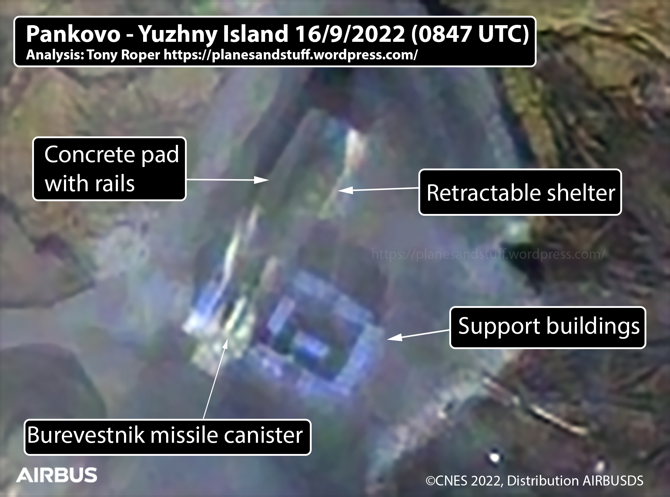
Pankovo test facility DOES have retractable shelter
Burevestnik missile canister captured in imagery on test ramp
Test could be imminent
I never was happy with the Airbus imagery I received for the previous blogs. I felt the that some of the areas had been overexposed and had been blown out, into a white blob.
One of these areas was at the test ramp at Pankovo.
This was confirmed to me not too long after the update blog where I had presumed some sort of cover had been used at the test ramp as part of the construction process.
I was sent imagery (that I can’t publish here) that showed that the ramp DID have a retractable shelter. What I thought was a small door in the shelter was in fact a difference in the concrete ramp tied together with shadows creating that effect. The shelter is appears to be open at all times.
After complaining about the imagery I did get a small refund but decided to keep an eye out on Planet imagery for the same area. This is normally better quality than Airbus.
However, whenever Planet’s SkySat imagery was collected, it was always cloud covered at Pankovo.
I finally tried again with Airbus on 16 September 2022 having given up on Planet. The imagery was better – though nowhere near as good as that I’d been sent privately. This is despite the resolution being the same – 50 cm!
But it was good enough to prove that Burevestnik is present at Pankovo and appears to be close to being tested. The shelter was pushed back and a Burevestnik container was in position.
The canister is located between two raised walkways positioned either side. It appears to be on its trolley or loader system as shown below taken from Defense Updates YouTube video. The canister extends to just inside the entrance of the shelter.
Pretty much everything else described in the previous blogs is as stated.
At the first set of buildings south of the test area – the “gate house” as I called it – nothing has changed. There is definitely a frame there which could be for another building or shelter. Or, another thought I’ve has is that it is an antenna tower laying on its side waiting to be raised. Time will tell on this.
Further south, along the gravel road, the area containing the two white shelters with access ramps showed little change. However, the better quality does now highlight a trailer parked at the northern shelter. This is 13 metres in length and could possibly be a transporter for the missiles or a fuel truck for the booster section of the missile
The theory is that the shelters are readiness shelters for preparing Burevestnik for testing before moving them up to the test area.
Little has changed at the southernmost building, and is missed from this analysis. Looking at this area in closer detail, rather than being a power or generator building for the facilities, it could equally be a small area for holding the nuclear systems used in Burevestnik. Again, further assessment is required here.
With this new update it is worth keeping an eye out for navigational warnings for the Novaya Zemlya region. As it appears a missile is in the retractable shelter a test could be very imminent.
Whilst the imagery showed some major changes to the Pankovo site, it didn’t provide any real evidence that a test was going to be carried out soon.
The reason for looking at Pankovo in the first place was down to Russian maritime warnings (PRIPs) and NOTAMs that covered the area on and surrounding Novaya Zemlya. Between them, the warnings covered dates up until 9 September 2022. One day does remain for some of the warnings – the NOTAMs having expired on 5 September. Up until that time there had been no news from Russian sources that claimed any testing from the islands had taken place. This I would have expected had they done so.
I obtained imagery of Pankovo for 6 September 2022, extending the search further south of the test site.
Between here and the beach/harbour area, several group of buildings have been in the construction process from early 2020 – certainly the first real signs of construction show on Sentinel from July 2020. Moreover, foundation work and ground clearing had started in 2019.
At the test site there is one thing of note that changes the previous analysis in the last blog. What I thought was a raised platform or ramp in the 28 August imagery – and then an additional structure in the 2 September imagery – were in fact one and the same. The structure was always there, it is possibly under a white cover that stretched its entirety. In the latest imagery you can see that if it is a cover it has been partially pulled off the structure to reveal it underneath.
However, most of the new roads and test area are still raised. New equipment has arrived at the southern part of the test area since the last imagery.
The potential retractable shelter looks more permanent than first assessed and has a clear entranceway to the south. This structure could be an environmental entrance linking to the other blue areas. There does not appear to be any rails for retractable shelters, however these may be being placed under the blue north-eastern structure. Time will tell.
At the building 1.5 km south of the test site there is little to show what it’s purpose is. For now I’m calling it the “guard house/access gate” but I highly suspect this isn’t correct. There is a communications mast with what looks like microwave antennas installed, pointing north/south going by the shadows. It is approximately 50 metres in length, a little less in width./
A significant number of tracks lead cross-country from this site out to the NE. When following these, they appear to lead to nowhere, splitting off further on the routes.
There is also what looks like a white framed structure here, possibly for a further building not yet completed.
Where things get more interesting is further down the road, heading south to the old harbour bay and beach.
Another 1.8 km south from the “gate house” is a construction site with two white structures – each approximately 30 metres in length. These are placed to the west of the road with each having two vehicle access ramps – one at each end of the building. Whilst possibly drive through shelters, the ramps are offset from each other.
At least one helicopter pad is present with what looks like a MIL Mi-8 helicopter parked there at the time if the collection. There’s possibly another to the east of the road, but it could equally be the foundations of another building.
Drive about another 1 km south and you get to another new group of buildings, joined together by a corridor. As a whole, the buildings measure approximately 130 x 40 metres. This complex has the feel of a generator building though it can’t be fully determined at this time. The southern side of it does appear to have five or six blue fuel tanks in place. It certainly looks like a utilities building of some kind.
Proceed 1.5 km south and you arrive at the beach and “harbour” area. This has had long-abandoned buildings on the beach for some considerable time, though the area has been used in the summer months for gaining access to the test site and some of the better buildings used for short-term accommodation.
The imagery shows a considerable upgrade is taking place here. The old jetty, which was in ruins to be honest, has been replaced with a new one – be it with the same small footprint of the old one. The causeway to the jetty has been upgraded and potentially a new building footprint has been carved out at the old village. This could equally be a small quarry for sourcing hardcore for the tracks. Again, time will tell on this.
A large helicopter parking area has been established, with a MIL Mi-26 located here at the time of the collection. There’s a further helicopter pad at the northern group of buildings away from the beach. Communication masts are located at the village next to the helicopter parking area.
Overall, a considerable amount of work is going on at Novaya Zemlya. However, at this time, I don’t think the area is ready for any missile tests – and it could well be another few years before it is ready.
The weather here gives them about 5 real months of construction time a year – and this could be pushing it. Once winter sets in, it will be impossible for any work to take place.
So, what of the navigational warnings if the islands aren’t being used for Burevestnik?
A little more investigation did find the likely reason for the first set of warnings.
Project 1144.2 Kirov class CGHMN Pyotr Velikiy carried out a test launch of a P‐700 3K-45/3M-45 Granit (SS‐N‐19 “Shipwreck”) SLCM at a target located off the coast of Novaya Zemlya on 24 August 2022 – the day the navigational warnings started. The ship also carried out general weapons handling in the area with anti-aircraft missiles and artillery firing at airborne targets. It is possible it also used its 2 AK-130 130 mm guns for targeting land targets. This would explain the warnings that covered the island.
It also worked with another ship in the area – likely to have been Project 956A Sovremenny class DDGHM Admiral Ushakov.
The Russian MoD stated that airspace around Novaya Zemlya was closed for this activity. They also stated the Granit test was a success, hitting the target located 200 km away.
Also operating in the area at the time were Project 1155 Udaloy class DDGHM Admiral Levchenko and Project 775 Ropucha class LSTM Alexander Otrakovskiy – along with support ships Project 1559V Boris Chilikin class replenishment ship Sergei Osipov and Project 1452 Ingul class salvage tug Pamir.
These were further north than Novaya Zemlya, operating off Franz Josef Land, for some of this time period. They then carried out a southbound transit west of Novaya Zemlya to the Gazpromneft’shel’f to carry out a security exercise at the Prirazlomnaya marine ice-resistant station located at 68.83523259654382, 58.14904110488897. The exercise simulated a terrorist attack at the station, with Levchenko sending a Ka-27 helicopter with special forces on board to resolve the situation.
The transit from Franz Josef took place exactly during the navigational warnings which means they too could have carried out weapons exercises during this period. They have now gone further east into the Kara Sea and and have carried out various combat exercises.
Two new NOTAMs that expire at 2100 UTC on 9 September 2022 now cover the area to the west of Novaya Zemlya.
The shape, length and altitudes of these two warnings point to a missile test, but sea- launched at a target over or on the sea surface – rather than on Novaya Zemlya.
According to the latest information, Pyotr Velikiy is still operating in the area.
This latest imagery, for me, concludes that Novaya Zemlya is not ready for testing Burevestnik – and won’t be for the foreseeable future – but the area continues to be one that is used for a multitude of different weapons tests as it has been for decades.
Satellite imagery shows changes at Pankovo test site
Possible Burevestnik test
On 20 August 2022, the Russian navy posted a PRIP/Navigation warning for the area surrounding Novaya Zemlya. These warnings are always of interest as they normally highlight some sort of weapons firing or testing from the island into the Barents Sea.
The warning extended from 24 August until 9 September.
@The_Lookout_N on Twitter kindly posted the PRIP and plotted the positions. This showed most of the islands covered by the warning.
New highly interesting PRIP around Novaya Zemlya, active between August 24th and September 9th.
There is a possibility this is related to tests of the 9M730 Burevestnik nuclear-powered cruise missile from Pankovo.
Normally a NOTAM follows these warnings should there be any kind of weapons firing and sure enough, on 27 August, a NOTAM did appear. This only covered the period up to 30 August however.
The PRIP had already got me searching for imagery for the Pankovo test site – located at 73° 6’52.60″N 53°16’28.38″E – and one of the areas I check fairly regularly for new imagery on Google Earth (not much luck there to be honest!).
Novaya Zemlya has been used for several tests in the past. Most notably, during Soviet times, for nuclear weapons testing – including the RDS-202, the most powerful thermonuclear weapon ever tested.
Pankovo is associated with the 9M730 Burevestnik (SSC-X-9 “Skyfall”) nuclear-powered cruise missile. Tests began at Pankovo in 2017, with two reported. Both are thought to have failed, though a video does exist of the November 2017 test that depicts the missile being launched and flying along the Novaya Zemlya coastline.
In August 2019, a test at the Nenoksa test facility on the White Sea resulted in an explosion that killed five Rosatom technicians. A release of radiation from this hints at the test of Burevestnik. The facility at Nenoksa has similarities to those from the 2017 tests in Pankovo.
I covered the Nenoksa site in a Janes Intelligence Review (JIR) article in October 2020.
Probable Burevestnik test site, Nenoksa. Imagery is dated March 2020 according to Google Earth
Following the 2017 tests of Burevestnik at Pankovo, in July 2018, most of the site was dismantled, with just the old buildings used for accommodation remaining. The test area had consisted of several temporary support shelters and a retractable shelter to cover the missile. This shelter was placed on rails approximately 50 metres in length which were, themselves, placed on a concrete pad.
The dismantling of Pankovo, and the subsequent new site at Nenoksa, looked as if the tests were to continue at the White Sea site rather than at the remoter Novaya Zemlya location. The 2019 incident, however, may have made the Russians change their mind on this.
With the PRIP and NOTAM in place, I decided to download several images that covered the times in the warnings.
These currently cover 22 August 2022 to 2 September 2022.
The first NOTAM expired on 30 August, as previously stated, however new ones were published that covered 31 August to 5 September.
The imagery highlights several things.
Firstly, the test area has been changed. In 22 August imagery, the concrete launch area and rails have been removed and realigned – turning approximately 10 degrees to point further southwest. The pad also appears to have been raised. It cannot be determined whether any rails are in place.
The temporary support buildings/shelters are in place again – as is a possible retractable shelter for the missile itself. This is smaller than both the previous shelter here in 2017, and the one at Nenoksa.
However, on 2 September 2022, a new support structure or container was located at the far end of the new concrete pad. Whether this contains a Burevestnik or other missile under test cannot be established.
With a day to go until the PRIP and NOTAM expire, it is now a case of waiting to see what transpires.
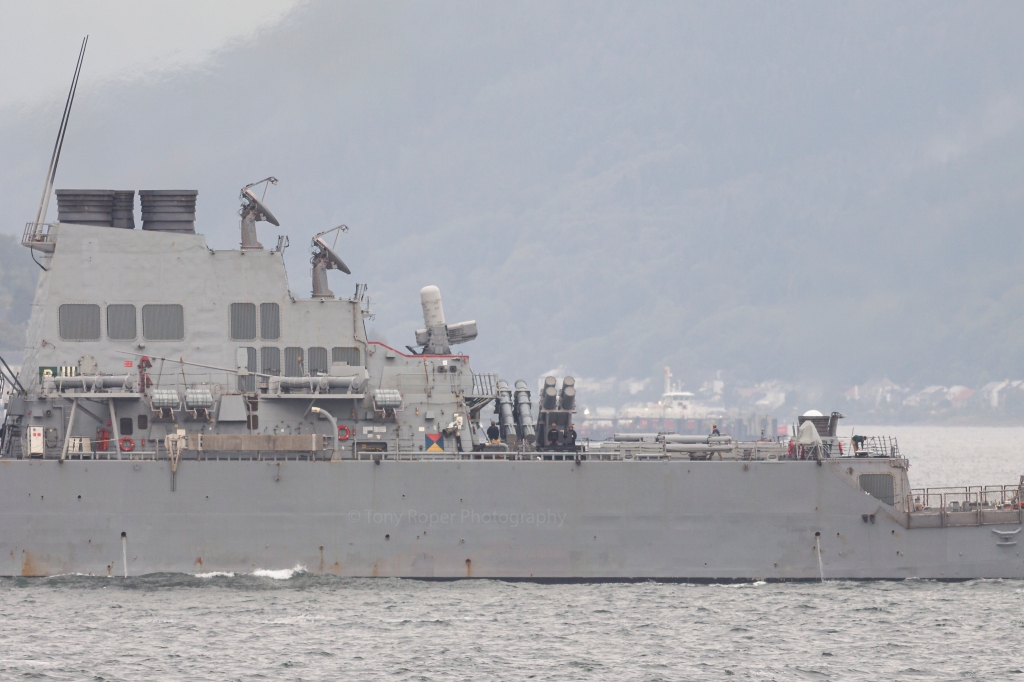
Interestingly, NATO are also about to carry out an exercise themselves – off the coast of the UK. This “SINKEX” involves several ships, though it will be run by the US Navy as the main aim of the exercise will be to test a new US targeting satellite. It is reported that several Harpoon missiles will be fired at ex Oliver Hazard Perry-class FFG USS Boone. One ship slated to fire is Royal Navy Duke (Type 23) class FFGHM HMS Westminster.
US Navy Arleigh Burke class USS Arleigh Burke paid a quick one day visit to HMNB Clyde (Faslane) on the 2nd and 3rd of September 2022 – also associated with the SINKEX.
In that blog I made a typo. For every word where I meant to say Su-24, I said Su-23. This included in the satellite imagery labelling. So how could this possibly happen as I knew fully that they were Su-24s? I’d called them this correctly in the blog before that and regardless – I know what a Su-24 is.
To add salt to the wound of the error, on my desk next to me at the time of doing the analysis, I had the excellent books by Yefim Gordon & D Komissarov Sukhoi Su-24 and Sukhoi Su-27 & 30/33/34/35. They were still on my desk in the morning when I got up. I’d had the idea on going into a little detail about the aircraft themselves, but changed my mind.
The books still on my desk in the morning.
Looking back at the creation of the blog, I’m pretty sure I know what happened. When I started working on the imagery, when I typed in the first Su-24 label, I inadvertently typed Su-23. This could have been in error by hitting the 3 key instead of the 4, or by just stupidly typing it incorrectly.
From there, the rest is history. I copy/pasted the label for the others in the imagery, and this is where the brain takes over. I subconsciously took in Su-23 as being correct – regardless of knowing what they were, and having pointers near me to correct the mistake (including checking back on the other imagery and blog looking for changes).
Moreover, when it came to proof reading the whole thing, it still slipped through the net again. I even found other mistakes that I rectified.
In other words I totally believed what I was typing and had typed was correct, even though subconsciously I knew it was wrong. And I let it pass – I was seeing what I wanted to see
In my daytime Air Traffic Control world we use the well known term confirmation bias for this.
What is interesting about the whole thing is that just two hours before, in a busy radar session, I was calling a couple of aircraft by the wrong callsign. This is extremely common for us, and for pilots too.
To explain. We have radar screens with data-blocks that show the aircraft callsign, altitude/level, selected level in the flight management system on the aircraft (via ADS-B) and the exit code from UK airspace or last two letters of the destination airfield. We have plenty of other things available to us via Mode-S, but these are selectable.
We also have electronic flight progress strips (eFPS) which has plenty more info on, but the callsign is the obvious one and what I want to look at here.
I can’t remember the exact callsigns, but take an example of EZY12QC – “Easy one two quebec charlie“. I called this one “Easy one two quebec golf” on its first contact, and despite having a eFPS and radar that i was fully interacting with, I continued to do so. It didn’t matter what was in front of me, it was “quebec golf”, not “quebec charlie”. There was at least another flight like that. All was safe as it was checked by the aircrew that the instructions were for them, but it adds extra workload and time to radio transmissions and getting the traffic moving.
An example of aircrew error is taking the wrong calls for other flights with similar callsigns – normally with the same airline, though inter-airline errors do occur. On one occasion, a flight I was working kept taking the call of another that was with the same airline. Eventually, after the fourth or fifth time, he apologised and said he’d been doing that flight the day before and couldn’t get it out of his head – despite coming from Spain and using the correct callsign up until then.
In ATC we use a combination of long term memory, and short term memory. The long term stuff is for things like procedures, sector frequencies etc. Airline callsigns come into this too – their actual airline callsign such as “Easy” for EasyJet, “Speedbird” for British Airways.
The short term stuff is things like co-ordinated agreements with other sectors, the actual traffic picture, flights on frequency etc.
Short term stuff we remove from our brains, once we have no use for it, but we keep the other stuff forever. I still remember things from RAF Lyneham when I was there in 1989!
And, of course, this isn’t an aviation thing. It is present in everything humans do in their lives.
So, how does this affect analysing imagery etc.?
With the last blog, it was probably a combination of being up since 7am, doing an afternoon shift finishing at 2200 UK time that included confirmation bias in the last hour – and then an hours drive home. In other words, a long, tiring day with a fuddled up brain already in place.
Going back to saying that we see what we want to see – analysing imagery has plenty of this.
Not everything of course, but occasionally it creeps in. And it happens to everyone.
I’ll take the Saki attack “aftermath” as a prime example of this as I think there’s several places this has happened. And I’m just going to say this now – this is not a direct dig at anyone in particular.
In fact, I’ll start with one of mine – or a possible one. I’ve been watching Saki since 2014 so know it pretty well I think. I also have access to some fantastic data on the base.
The two buildings destroyed at the revetments are known “workshops” used by the Russians for quick repairs to aircraft. Often this has entailed taking parts from one aircraft to put onto another to keep the fleet “airworthy”. This is likely why there was a Su-24 at the eastern building. Parts are stored in one of the revetments west of the building.
The two concrete parking areas also targeted were for vehicles, equipment and spare parts – often kept in boxes or crates. One has been referenced as a building in some analysis and on social media. This is completely wrong. You only have to look back through Google Earth history to see that often there are Su-24s parked there. But people are seeing what they want to see – and to be honest, being a little lazy and not checking themselves. It doesn’t take much to go back through GE history.
I have all this information stored in my head as long term memory and that is what I believe these areas are used for. At some stage over the last few months, and in particular over the last few days, these buildings and parking areas have become weapons storage areas according to reports and social media. Where this came from I have no idea, but certainly, since the attack they have been known as “ammo storage buildings”.
Likely, the main reason for this is because the number of boxes and crates has increased since the beginning of the war – and they’re green. My confirmation bias says these are all sorts of equipment, whereas others say they are ammo boxes because this is what they’ve read/been told; and their confirmation bias won’t say otherwise. Ammo boxes are being seen because they are green – and well, so are ammo boxes.
One of the concrete areas has white torpedo like objects. These are Su-24 3,000 litre external fuel tanks that they carry on the inner pylons, under the wings. In the aftermath imagery you can see they have been shifted by the power of the nearby explosion. These have been referenced to missiles in storage. They’re not.
In reality, we don’t actually know what was in these green boxes and crates. Logic tells me it isn’t all munitions as they have hardened areas specifically for this. But, the Russian forces do have open munitions storage areas located at bases all over the country so who is to say? More than likely, it will be a mix of things.
The real confirmation bias from this incident comes it at the main apron. The Planet imagery I provided for the morning before the attack showed three Su-24’s and three Su-30’s parked on the main flight line.
There are a number of things to note – referencing the first image below. Firstly, the aircraft follow white taxiway lines to a white square to stop and shut down. These squares are clearly visible where aircraft aren’t parked.
Secondly, next to each parking spot there is equipment used with the aircraft. Starter generators, wheel chocks, ladders and other things needed for the aircraft. These can be seen in between the parked aircraft in the imagery.
The last thing to note is that there isn’t an aircraft parked on the far west spot – this is the spot that in the post attack imagery there is supposedly a destroyed Su-24. As there’s no wreckage present, this can’t be confirmed 100%, but photos and video have been produced that do show a destroyed Su-24. Actually, in the post attack imagery the burnt area centres on the equipment between the parking spots.
Looking at the second image below you can clearly see all the equipment still in place. But many saw these as destroyed aircraft – and Hey, Presto! six more aircraft that are actually over to the east of the base have been destroyed!
Total confirmation bias – you are seeing what you want to see. Because we all want to see Russia fail (well not everyone, obviously).
And yet all the clues are there. At the probable destroyed Su-24 area, there’s a completely burnt out patch covering the parking squares – yet for the “other six” there isn’t. The obvious equipment – seen in imagery just 24 hours before – is ignored and declared as wrecks.
Whilst the aircraft that were on the flightline probably didn’t escape some damage, from confirmation bias we have claims that the whole fleet of aircraft were totally destroyed – and whilst it was a very successful attack – it wasn’t as successful as is claimed.
This leads to misinformation – and what I call ” Bad OSINT”.
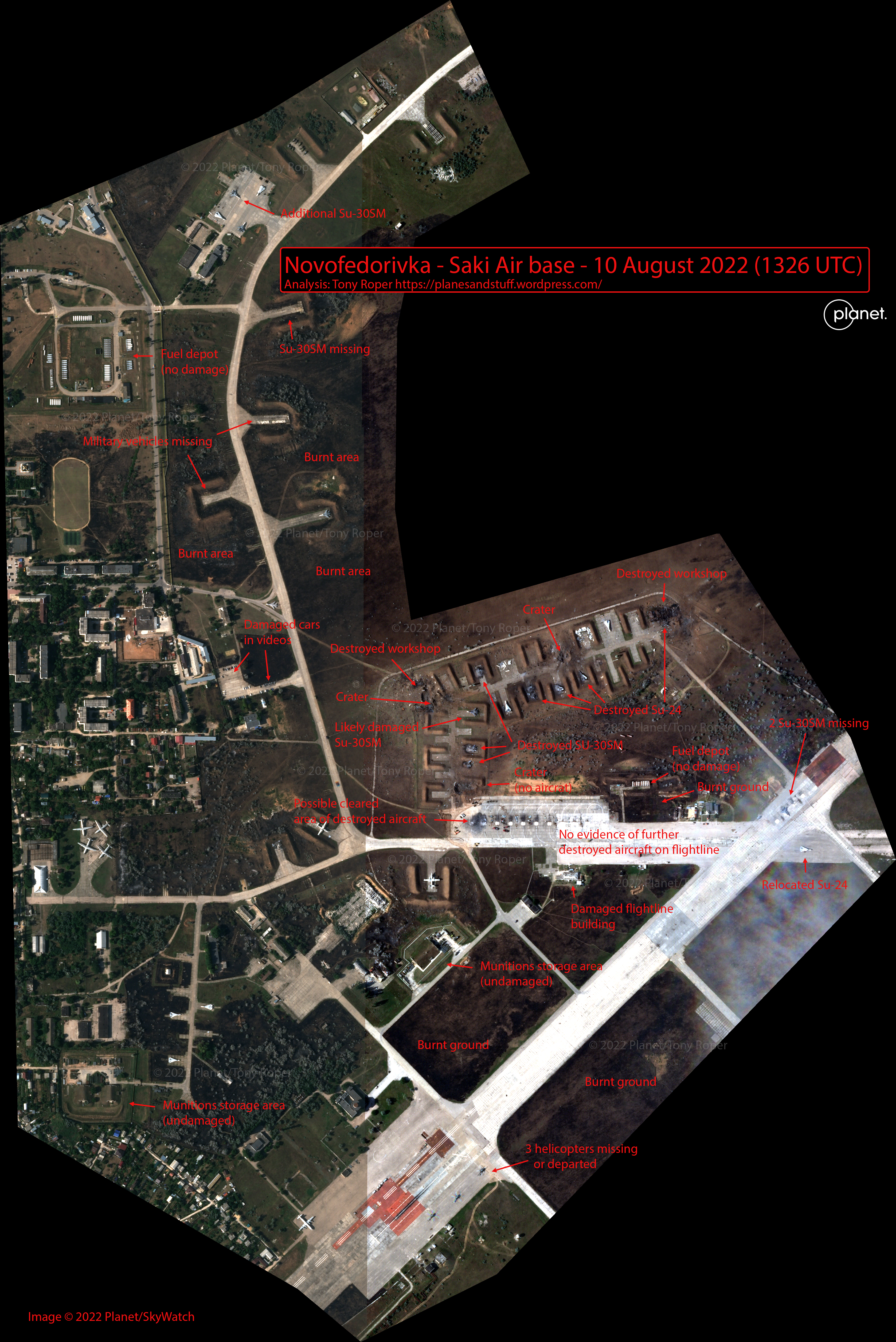
It took a long time in coming, but imagery is available of the destruction caused at Saki (Saky) air base in Crimea.
Unfortunately, being at real work has delayed this analysis, but it’s worth putting out there anyway. Plus the imagery shows the majority of the airfield rather than just the main parking area. This alone provides some interesting information.
Primarily, the 43rd Independent Naval Attack Aviation Regiment of the Black Sea fleet has taken a bit of a hit. Definitely, three Su-30SM’s have been destroyed with one probably damaged. Moreover, four Su-24’s are destroyed in the revetment area – with the possibility of another on the main apron.
The Su-24 on the apron is inconclusive. There’s definitely an area that has been cleared – there’s vehicles around it etc. – but the imagery from earlier in the day doesn’t show an aircraft in that actual spot.
Most certainly, no other aircraft were destroyed where they parked on the main flightline. This is obvious from the ability to see all the “parking squares” and lack of burnt areas. If a Su-24 (or other aircraft) was destroyed at the scorched area then they have removed the wreckage pretty quickly – possibly to hide what happened, but the rest of the airfield gives it all away.
Most of the aircraft destruction is in the revetments – ironically used to protect aircraft from events like this. If only the Russian’s used HAS’s (Hardened Air Shelters) – they may not be feeling the pain. The good news is, they are.
The revetments have given up three Su-24’s and three Su-30’s. A further Su-24 is destroyed at the eastern maintenance minor workshop shed.
And this is where it all gets interesting.
The actual targets.
Two minor workshop sheds have been totally targeted and destroyed. Moreover, two other areas that were targeted – or appeared to have been – were general parking areas used for vehicles and equipment.
It is strange that the two large munitions areas and the fuel depots were also not targeted. And to be honest, if an aircraft has been destroyed on the main flightline, I suspect this is from secondary explosions and fire rather than a direct strike as there is no crater present. Why wasn’t this area targeted?
The area around the parking revetments is dotted with small craters, possibly from debris. But they do look more like explosive craters rather than that caused by falling debris.
A vast majority of the airfield grass areas has been burnt. This could have potentially spread to the burnt out cars that have been seen in videos – though one has certainly been destroyed by debris from explosions. @wammezz on Twitter produced a false-colour image of the whole base which clearly shows the extent of the burnt ground.
We made a False-Color image with @planet Skysat of the attack on #Saki air base in Russian-occupied #Crimea to show the burn marks. Red indicates healthy vegetation, and black are the burn marks from post-explosions fires pic.twitter.com/GlO9iTtLEL
There’s been a number of aircraft movements since the event. A Su-30SM is now in the main maintenance area – possibly the one from the revetment nearby that is now missing. And whilst the number of Su-24’s in this area remain the same, either one has been removed/moved, or there’s been a change around.
Obviously, the main flightline has been emptied, as has the eastern secondary line, except for a single Su-30SM. A Su-23 has been relocated to just south of this area.
Three helicopters have departed, whilst the three remaining have been rotated to point east.
Due to costs I couldn’t get a full airfield view from Planet so it is possible some of the aircraft have been moved to the eastern airfield revetments.
There is still no conclusive evidence as to what was used in this attack.
I’ve always thought a Ukrainian SF mission – which I didn’t want to say in the other blog as it was still a recent event and there was a slight OPSEC concern with me to be honest. The Ukrainian armed forces have stated it was a SF mission also.
However, the craters visible do point to a missile strike, with a good friend betting a ATACMS strike.
I’m still torn.
Maybe the maintenance sheds held more than scrap parts of aircraft to keep the main line going from day to day. I’d like to say the Russians aren’t that stupid – but since March, they’ve clearly shown they are.
Whilst it is good to see the evidence of destruction in Crimea – finally – the event has almost created more questions than answers.