Analysing the analysis – a closer look at the Saki air base attack satellite imagery


Yesterday – or rather, in the early hours of today – I posted my last blog, Novofedorivka – Saki Air base attack satellite imagery – The aftermath.

In that blog I made a typo. For every word where I meant to say Su-24, I said Su-23. This included in the satellite imagery labelling. So how could this possibly happen as I knew fully that they were Su-24s? I’d called them this correctly in the blog before that and regardless – I know what a Su-24 is.

To add salt to the wound of the error, on my desk next to me at the time of doing the analysis, I had the excellent books by Yefim Gordon & D Komissarov Sukhoi Su-24 and Sukhoi Su-27 & 30/33/34/35. They were still on my desk in the morning when I got up. I’d had the idea on going into a little detail about the aircraft themselves, but changed my mind.

The books still on my desk in the morning.

Looking back at the creation of the blog, I’m pretty sure I know what happened. When I started working on the imagery, when I typed in the first Su-24 label, I inadvertently typed Su-23. This could have been in error by hitting the 3 key instead of the 4, or by just stupidly typing it incorrectly.

From there, the rest is history. I copy/pasted the label for the others in the imagery, and this is where the brain takes over. I subconsciously took in Su-23 as being correct – regardless of knowing what they were, and having pointers near me to correct the mistake (including checking back on the other imagery and blog looking for changes).

Moreover, when it came to proof reading the whole thing, it still slipped through the net again. I even found other mistakes that I rectified.

In other words I totally believed what I was typing and had typed was correct, even though subconsciously I knew it was wrong. And I let it pass – I was seeing what I wanted to see

In my daytime Air Traffic Control world we use the well known term confirmation bias for this.

What is interesting about the whole thing is that just two hours before, in a busy radar session, I was calling a couple of aircraft by the wrong callsign. This is extremely common for us, and for pilots too.

To explain. We have radar screens with data-blocks that show the aircraft callsign, altitude/level, selected level in the flight management system on the aircraft (via ADS-B) and the exit code from UK airspace or last two letters of the destination airfield. We have plenty of other things available to us via Mode-S, but these are selectable.

We also have electronic flight progress strips (eFPS) which has plenty more info on, but the callsign is the obvious one and what I want to look at here.

I can’t remember the exact callsigns, but take an example of EZY12QC – “Easy one two quebec charlie“. I called this one “Easy one two quebec golf” on its first contact, and despite having a eFPS and radar that i was fully interacting with, I continued to do so. It didn’t matter what was in front of me, it was “quebec golf”, not “quebec charlie”. There was at least another flight like that. All was safe as it was checked by the aircrew that the instructions were for them, but it adds extra workload and time to radio transmissions and getting the traffic moving.

An example of aircrew error is taking the wrong calls for other flights with similar callsigns – normally with the same airline, though inter-airline errors do occur. On one occasion, a flight I was working kept taking the call of another that was with the same airline. Eventually, after the fourth or fifth time, he apologised and said he’d been doing that flight the day before and couldn’t get it out of his head – despite coming from Spain and using the correct callsign up until then.

In ATC we use a combination of long term memory, and short term memory. The long term stuff is for things like procedures, sector frequencies etc. Airline callsigns come into this too – their actual airline callsign such as “Easy” for EasyJet, “Speedbird” for British Airways.

The short term stuff is things like co-ordinated agreements with other sectors, the actual traffic picture, flights on frequency etc.

Short term stuff we remove from our brains, once we have no use for it, but we keep the other stuff forever. I still remember things from RAF Lyneham when I was there in 1989!

And, of course, this isn’t an aviation thing. It is present in everything humans do in their lives.

So, how does this affect analysing imagery etc.?

With the last blog, it was probably a combination of being up since 7am, doing an afternoon shift finishing at 2200 UK time that included confirmation bias in the last hour – and then an hours drive home. In other words, a long, tiring day with a fuddled up brain already in place.

Going back to saying that we see what we want to see – analysing imagery has plenty of this.

Not everything of course, but occasionally it creeps in. And it happens to everyone.

I’ll take the Saki attack “aftermath” as a prime example of this as I think there’s several places this has happened. And I’m just going to say this now – this is not a direct dig at anyone in particular.

In fact, I’ll start with one of mine – or a possible one. I’ve been watching Saki since 2014 so know it pretty well I think. I also have access to some fantastic data on the base.

The two buildings destroyed at the revetments are known “workshops” used by the Russians for quick repairs to aircraft. Often this has entailed taking parts from one aircraft to put onto another to keep the fleet “airworthy”. This is likely why there was a Su-24 at the eastern building. Parts are stored in one of the revetments west of the building.

The two concrete parking areas also targeted were for vehicles, equipment and spare parts – often kept in boxes or crates. One has been referenced as a building in some analysis and on social media. This is completely wrong. You only have to look back through Google Earth history to see that often there are Su-24s parked there. But people are seeing what they want to see – and to be honest, being a little lazy and not checking themselves. It doesn’t take much to go back through GE history.

I have all this information stored in my head as long term memory and that is what I believe these areas are used for. At some stage over the last few months, and in particular over the last few days, these buildings and parking areas have become weapons storage areas according to reports and social media. Where this came from I have no idea, but certainly, since the attack they have been known as “ammo storage buildings”.

Likely, the main reason for this is because the number of boxes and crates has increased since the beginning of the war – and they’re green. My confirmation bias says these are all sorts of equipment, whereas others say they are ammo boxes because this is what they’ve read/been told; and their confirmation bias won’t say otherwise. Ammo boxes are being seen because they are green – and well, so are ammo boxes.

One of the concrete areas has white torpedo like objects. These are Su-24 3,000 litre external fuel tanks that they carry on the inner pylons, under the wings. In the aftermath imagery you can see they have been shifted by the power of the nearby explosion. These have been referenced to missiles in storage. They’re not.

In reality, we don’t actually know what was in these green boxes and crates. Logic tells me it isn’t all munitions as they have hardened areas specifically for this. But, the Russian forces do have open munitions storage areas located at bases all over the country so who is to say? More than likely, it will be a mix of things.

The real confirmation bias from this incident comes it at the main apron. The Planet imagery I provided for the morning before the attack showed three Su-24’s and three Su-30’s parked on the main flight line.

There are a number of things to note – referencing the first image below. Firstly, the aircraft follow white taxiway lines to a white square to stop and shut down. These squares are clearly visible where aircraft aren’t parked.

Secondly, next to each parking spot there is equipment used with the aircraft. Starter generators, wheel chocks, ladders and other things needed for the aircraft. These can be seen in between the parked aircraft in the imagery.

The last thing to note is that there isn’t an aircraft parked on the far west spot – this is the spot that in the post attack imagery there is supposedly a destroyed Su-24. As there’s no wreckage present, this can’t be confirmed 100%, but photos and video have been produced that do show a destroyed Su-24. Actually, in the post attack imagery the burnt area centres on the equipment between the parking spots.

Looking at the second image below you can clearly see all the equipment still in place. But many saw these as destroyed aircraft – and Hey, Presto! six more aircraft that are actually over to the east of the base have been destroyed!

Total confirmation bias – you are seeing what you want to see. Because we all want to see Russia fail (well not everyone, obviously).

And yet all the clues are there. At the probable destroyed Su-24 area, there’s a completely burnt out patch covering the parking squares – yet for the “other six” there isn’t. The obvious equipment – seen in imagery just 24 hours before – is ignored and declared as wrecks.

Whilst the aircraft that were on the flightline probably didn’t escape some damage, from confirmation bias we have claims that the whole fleet of aircraft were totally destroyed – and whilst it was a very successful attack – it wasn’t as successful as is claimed.

This leads to misinformation – and what I call ” Bad OSINT”.

Project 02690 class floating crane SPK-54150 returns to Snake Island

According to satellite imagery made available by Planet, Project 02690 class floating crane SPK-54150 – based at Sevastopol for the Russian Black Sea Fleet – has returned to Snake Island on, or before, 15 May 2022.

Low resolution imagery from Planet shows Project 02690 class floating crane at Snake Island Harbour on 15 May 2022

The whereabouts of SPK-54150 between today and when it departed the area on 12 May 2022 is unknown, but imagery from Sentinel dated 14 May 2022 shows it returning to the island.

Located at 45.224993 30.744780, the shape, colour and size of the floating crane can be clearly seen. The wake behind also shows the very slow speed it is travelling at – the class averages a speed of 6 knots generally.

Collected at 0857z, the floating crane is approximately 42 kilometres away from Snake Island – or 23 nautical miles.

Based on the average speed of 6 knots, it is actually more likely that SPK-54150 arrived around 1230z on the 14th. Obviously, this if it went direct from the spot located. Imagery is not available of Snake Island on 14 May 2022 later than this as far as I’m aware.

The resolution of the imagery available to me doesn’t show whether the floating crane has any cargo. No doubt further high resolution imagery will appear soon.

Vsevolod Bobrov – More fake news

On 12 May 2022, reports starting coming in on Twitter about yet another attack on a Russian ship in the Black sea.

This time it was Project 23120 logistics support vessel Vsevolod Bobrov that was making the news.

Commissioned to the Black Sea fleet on 6 August 2021, Bobrov is one of the most capable and modern supply ships in the Russian Navy. To lose a ship like this would be quite a blow.

The ship has a displacement of 9,700 tonnes, measures 95 m in length and has a maximum speed of 18 kts. It has a range of 5,000 nautical miles or an endurance of 60 days. Ordinarily it has crew of 55.

The 700 m2 cargo deck can carry approximately 3,000 tonnes of cargo and is equipped with two 50 tonne electro-hydraulic cranes. Moreover, main and auxiliary towing winches are capable of a pulling capacity of 120 tonnes and 25 tonnes.

The reports of an attack, of course, was yet more fake news emanating from “Ukrainian Sources”.

Whilst I understand the need for propaganda in this war, stories such as these do not help with the Russian’s denial of any sort of atrocities etc. They can just prove stories such as these are fake, and therefore say all the others are too. Moreover, there is no real need to do it – the Ukrainians are causing enough damage as it is, there’s no need to make any up.

Regardless, it was another “story” I didn’t believe in the first place.

Whilst Bobrov is operational in the Black Sea, the “Ukrainian sources” provided even less information than normal – there wasn’t even an attempt at a fake video.

Therefore, it was just a case of sitting back and waiting for the ship to arrive in Sevastopol. And sure enough, it did!

Images of Bobrov alongside at Sevastopol on 14 May 2022 were made available on Twitter the same day. The images themselves were taken from a Telegram account, Black Sea Fleet, and clearly show no damage whatsoever to Bobrov.

If anything it is near mint condition.

On closer inspection, it can be seen that a Pantsir-S (NATO SA-22 Greyhound) self-propelled surface to air gun and missile system is located between the two cranes. One of the access hatches is open, and a Z can been seen drawn on the side.

Whether the AD system is there for the ship’s own protection or was part of a cargo is not known. However, satellite imagery shown to me which I cannot show here has the system moved to the stern of the ship. This does make it look like the system is there to protect the ship – it doesn’t have any in normal circumstances.

How useful the AD system would be is anyone’s guess and is probably more for show than anything else – or at least to make the crew feel safe. The height of the cranes to the side, and the main structure of the ship forward, would make it extremely hard to defend any attacks from these directions – unless they were directly, or near directly, above.

Pantsir-S highlighted in image provided by Telegram account – Black Sea Fleet

This is possibly a trend though. The Project 02690 class floating crane that was at Snake Island on 12 May 2022 – now departed the area – also had an AD unit on its deck. It is not known though whether this was later offloaded to the island or not.

I’m sure further evidence will be made available on whether the use of mobile AD systems is a thing or not with Russian navy ships not equipped with built-in systems..

Snake Island – further activity

**Updated**

Despite heavy losses at Snake Island, Russian forces continue to operate at the island.

Imagery made available by Maxar shows a Project 02690 class floating crane operating at the island’s harbour – along with a Project 11770 Serna class landing craft.

Maxar imagery showing Project 02690 class floating crane operating at Snake Island harbour. The wreck of the Project 11770 Serna class landing craft can be clearly seen, still carrying its cargo. A further Serna class is at the landing slipway, with its ramp lowered.

The theory on social media is that the floating crane is there to recover the sunk Serna class landing craft. This is probably unlikely as in theory the weight of the ship and its cargo (likely one of the 9K331M Tor-M2 family of SAM systems) combined with the sea would take the lifting weight outside of that capable by the crane – **See below for update**

Two options are more likely. Either to recover the 9K331M Tor-M2; or to be used to transfer cargo from other ships to – or from – the island.

It is a risky operation. The floating cranes are not very maneuverable or fast. Their average speed is 6 kts.

Further imagery of the area shows another Serna class operating close to the island. Some thought “clouds” near the ship were smoke trails from Ukrainian missiles attacking the ship. This isn’t the case and it is possible the ship is dispensing smoke to try and cover/protect the operations taking place at the island.

This is clearly failing.

Getting back to the crane and the image of it operating off the harbour jetty.

There is a possibly a 9K331M Tor-M2 is on the deck. More of these have been located on the island so it does appear the crane has either assisted in, or transported, these. How long they last is another question?

Through analysis of satellite imagery from Capella Space and Sentinel, and in conjunction with historic AIS data from FleetMon, it is likely the floating crane is SPK-54150.

Capella SAR imagery dated 11 May 2022 shows a floating crane in the Pivdenna Bay area of Sevastopol.

A colour, low resolution image from sentinel for the same day shows the floating crane – the yellow colour of the crane is clearly visible.

A search of AIS data in FleetMon for the two known floating cranes operating for the Black Sea Fleet – SPK-54150 and SPK-46150 – produced an outcome for both.

SPK-54150 was last “heard” on 10 May 2022 tracking Northwest at 6 kts, not far from Karadzhyns’ka bay. I have access to S-AIS from FleetMon so this last heard means the ship switched off its AIS at this time – the data list confirms it was transmitting via Satellite.

Data from FleetMon shows SPK-54150 was using S-AIS from the symbol at the end of each line

On the other hand, the AIS for SPK-46150 was last heard on 26 March 2022. It does appear to have stayed here since then – or been operational but not used its AIS and returned to the same spot each time.

From this data then, we can conclude the floating crane is likely to be SPK-54150.

As previously mentioned, the use of the floating cranes shows a certain desperation with the Russian forces to maintain a presence on Snake Island.

It really does appear they want to stay there, no matter the risks and potential costs.

**Update**

Eventually, the floating crane did recover the Serna class from the harbour. A pretty good job too as this – as I stated above – would have been at the edges of the cranes capabilities. Not known is wether it recovered the “cargo” first.

The Snake Island attacks – Part Two

In my last blog, I tried to highlight the issues with analysing imagery and videos with only half a story.

I also tried to draw the attention to how fake videos can make one look at others with a lot of doubt as to whether they are real or not.

I concluded that more evidence was needed – in particular high resolution imagery from Maxar or Planet.

The good news is, that not long after the blog was posted, I was anonymously sent an image dated 7th May 2022 taken from either Maxar or Planet – the source didn’t say.

This clearly showed the wreck of the Project 11770 Serna class landing craft in the Snake Island harbour. It also showed the concrete blocks I wanted to see. This was useful as had the image been collected from before the attack, and there been no wreck, then at least the location was pretty much confirmed.

Even the blocks would have been enough then to conclude that the video was legitimate.

It wasn’t long after I received the image that it was published by AP, and shown on Twitter.

For those that don’t have Twitter access – Jon’s account is locked – here’s the image.

I also received a notification from a friend, Scott Tilley – well worth following on Twitter if you don’t. His satellite tracking capabilities and knowledge is fantastic.

His notification pointed me to a website that contained photographs of Snake Island – some of which depicted the concrete blocks used as the sea defences. A great find – and one that had slipped through my rushed searches.

So, hopefully this shows how information can take it’s time to get through to carry out a full analysis.

There’s reasons why the Intelligence services take their time over gathering data on incidents such as this.

Now, as further videos are coming through thick and fast of attacks on Snake Island, more confidence can be had over their legitimacy.

The wingman in this attack is probably very lucky not to have been taken out by the explosion created by the flight leader.

One has to question why the Russian forces are intent in staying at Snake Island. Their losses, I’d say, are greater than those taken by Ukraine.

My friend Capt(N) provided some information on the island in a recent Twitter thread. I’ve taken screenshots here as, again, not everyone uses Twitter.

The thread can be read here.

The Snake Island attacks – Part One

Whilst there is no doubt there have been several attacks on Russian equipment on Snake Island, in the last few days, some dubious video footage has been “leaked” on Twitter showing Russian ships under attack.

These videos do put into question those that do appear to be genuine.

For example, yesterdays – 6/5/22 – “news” that Project 11356M Admiral Grigorovich class FFGH Admiral Makarov was struck by multiple Neptune missiles immediately reminded me of the same claim against Project 22160 Corvette Vasily Bykov at the beginning of March, be it with MLRS weapons rather than the Neptune missiles.

I personally wasn’t convinced about the Makarov attack, and once further ridiculous Tweets materialised using ADSB data from FlightRadar24 (FR24) showing NATO aircraft “monitoring the situation” as proof that “something was going on” – well, I definitely didn’t believe it.

This is just poor “analysis” by people who haven’t got a clue what they’re talking about and should just not bother saying anything. Two examples below.

Unfortunately, the Ukraine war has brought out a substantial number of idiots that are suddenly “experts” in warfare, aircraft tracking, ship tracking and satellite imagery analysis. In reality, they are just plain fools.

And as Ben Kenobi says in Star Wars – “Who’s the more foolish? The fool or the fool that follows him?”

This is the problem with social media. These people have a “show” that they’re experts, and then they get thousands of followers that believe everything they come up with.

Personally, I don’t trust anyone with OSINT in the username.

This idiocy was highlighted when a video appeared, apparently from a TB2, showing Admiral Makarov on fire. This was clearly fake and taken from a video game – later identified as ARMA 3. One account on Twitter was able to recreate pretty much the same “video” in a matter of minutes.

So, whilst evidence of attacks are a good thing to have to assess whether losses have been taken or not – fake videos tend to sway people in the other direction.

Going back a few days, I believed the Project 03160 Raptor fast patrol boat attacks video from the 2nd of May – but the above now has me thinking otherwise. I did find it a little strange that the second Raptor hung around the area for so long, and didn’t really make much attempt to evade a potential strike. This highlights the problems with creating fake videos for propaganda – once one fake video appears, it makes others seem fake too – whether they are not.

Todays video of the Project 11770 Serna class landing craft being attacked at the Snake Island harbour area certainly got my “fake video” senses twitching when I saw it. Mainly because, by sheer coincidence, I’d obtained imagery of Snake Island from Capella Space, collected on the 4th May, and I’d taken a good look at the harbour area to search for any evidence of ship activity there.

Coupled with the potential fake videos from previous “attacks” one can start to see inconsistencies in this video.

One thing – I always say this regarding my analysis work – I can’t always be right. I like to be, and I take my time on it, but errors will creep in every now and again.

So let’s look at what I see in the imagery versus the video and I can lay my cards on the table with my thoughts – and as always, I’m open to any comments.

First of all, one link to the video on Twitter. It is also available on YouTube I believe.

A number things immediately grabbed my attention. It is visible even in the Twitter image above. All those blocks of squares and rectangles. They look like CGI – too perfect. That area gets pummelled by the sea most of the time. Granted, they could be containers just dumped into the sea, but I’m not convinced at this.

Also, the ramp to the sea looks too perfect – very straight lines, no sea lapping over it. The wall that runs along it, into the sea, is new.

Let’s look at some close-ups from the video.

This one above shows yet more blocks east of the ramp, and strange grooves, much like seating areas. No sea lapping over them.

The next two shows the same area from nearly directly above. Note the near perfect lines of the walls, and more importantly, these blocks again. What are they? Not containers. Maybe concrete block sea defences??

The next image gives an overall view of the harbour area. Note the blocks again, and the coastline itself.

Now let’s look at the Capella imagery.

Whilst not perfect – typically the worst part of the imagery is the harbour – the blocks in theory would stand out. There doesn’t appear to be any. The quality is enough to show the jaggedness of the rocks along the coast, but not much else. There does not appear to be a wall out to sea along the ramp – but this is inconclusive in this imagery.

We can move onto some hi-res imagery from Maxar, though I’m afraid to say I have no contract with them and so I have had to use images from elsewhere. Ideally, we could do with someone that does have a Maxar account – or Maxar themselves – to provide us with the high-res imagery.

The first is taken from a CNN article dated 14th March 2022 and states the image was collected on the 13th. I’ve had to zoom in a little for the screen grab.

Not ideal quality, but does it look like there’s been much of an upgrade to the harbour area? It doesn’t look like there has been. It’s hard to determine whether there are any blocks there.

The following image is reportedly from Planet, collected in the last few days, and published by Associated Press – AP. Whilst I couldn’t find a direct link, there’s plenty out there – for instance.

Moreover, searching in the Maxar archive, there has been a collection on 7th May 2022 which shows smoke coming from the building as shown above, just on the left edge. Note also the ship activity to the west of the island.

With these two images nearly aligning, we can conclude that the top image is very recent.

In my view, whilst there are small buildings near the harbour, one of which in the area east of the ramp – there appears to be no large blocks present. The wall into the sea by the ramp does appear to be present, but hard to determine whether it matches that in the video. It is still too hard to conclude from the imagery currently available whether the blocks are there or not.

Ideally now, then, we need that hi-res imagery that Maxar clearly has (note they’ve redacted the archive imagery of the island). Then we can put this one to bed once and for all.

Analysis isn’t just about seeing what is immediately in front of you. It is much, much deeper than that. Below sums it up nicely.

Just because it looks like Snake Island harbour in the video, doesn’t necessarily mean it is. You have to look at more than just the shape and the jetty.

Ironically, one proven event – the sinking of Moskva – is still to produce any video evidence that a missile attack led to its demise.

Say of that, what you want.

For what it’s worth…..


  • Project 677 Lada-class SSK Sankt Peterburg still in Kronstadt
  • Imagery proves early fake news prior to recent events around Ukraine borders

For what it’s worth….. indeed.

This imagery provided by Capella Space was supposed to have been in a Janes article last week, but the events surrounding Ukraine snowballed so quickly, it almost became old news before it had even really been put out there.

Anyway, rather than letting the imagery collection go to waste, Capella and I decided to include it here to add to the records of fake news put out by Russian media and pro-Russian supporters with regards to events in Ukraine, the Black Sea and Mediterranean.

To quickly recap, Russian news media outlet Izvestia claimed on 14 February 2022 that Russian navy Project 677 Lada-class SSK Sankt Peterburg had entered the Mediterranean Sea over the previous weekend “as part of large-scale exercises of the Russian Navy”. They quoted a source in the Russian defense department, stating “Together with a detachment of ships of the Northern Fleet, she will take part in manoeuvres in conditions “close to combat”[sic] “.

For this to have happened without being noticed is impossible. To have exited the Baltic Sea the SSK would have had to have transited via one of two routes between Sweden and Denmark – either via the Storebaelt bridge or the Oresund. It would also have had to have remained surfaced for the entirety of the transit. Had it done so it would have been seen either by the numerous ship enthusiasts that regularly take photographs of Russian – and other – warships; or by several webcams that operate on and in the vicinity of the Storebaelt bridge. There is no such evidence from these sources.

Many of us said the above at the time, both privately, and on Social Media. Covert Shores ran much the same story as here on the day without any satellite imagery – it was that quickly dismissed as fake news!

I requested an imagery collection from Capella Space almost immediately, and they were able to produce imagery at the next pass available, which was first thing in the morning UK time on 17 February.

The imagery provided clearly shows Sankt Peterburg still at its usual mooring position in Kronstadt, along with at least one Kilo-class SSK on the opposite side of the jetty. It’s highly likely another Kilo is tied up alongside the Lada-class.

Kronstadt has had near 100% cloud cover for well over a month making the collection of EO imagery from sources such as Sentinel impossible to use to verify the movements around the base.

This at least finalises the story as exactly what it was – a story.

More information on “Bastion-P” Matua Island deployment


  • Deployment day is now known
  • Maxar and Sentinel capture deployment
  • Identity of ships involved now known

Following on from my previous blog on the deployment of Russian K-300P “Bastion-P” mobile coastal defence missile unit to Matua Island, further satellite imagery from Sentinel and Maxar has been found showing the deployment taking place.

Moreover, the Maxar imagey has captured the actual moment the equipment exits the Pacific Fleet Project 775M Ropucha class Large landing ship – and in such detail you can clearly see the personnel filming the event.

The first thing ascertained is that the deployment took place on November 16th 2021, so the Russian MoD took two weeks to release the news. It is also now confirmed that all the support vehicles and personnel deployed at the same time rather than at an earlier date – which I suggested may have been the case in the previous blog.

If you watched the video from the Russian MoD in my last blog, at the beginning of it a Monolit-B mobile coastal surveillance radar vehicle exits the Ropucha class landing ship. The Maxar image clearly shows the Monolit-B on the beach having passed the “film crew”, and a K-300P just exited the ship and still in the breakwater.

Satellite image ©2021 Maxar Technologies.

The Ropucha can also be clearly identified as Admiral Nevelsky [055].

Imagery of the base for November 16th – the same as that from the ROLES article mentioned in my previous blog – shows little going on so it is likely that a small group of personnel were already there to set up the base, but very little else. However, it is good to get a high resolution of the image now.

Satellite image ©2021 Maxar Technologies.

Of interest is just how lucky a capture this was. Going through Sentinel-2 imagery, the weather before the 16th, up to today (December 9th), has been cloudy for the vast majority of the time. This is the drawback to normal EO imagery, and is why the SAR imagery capabilities of Capella is important to modern intelligence gathering using satellite imagery.

The Capella image from the 3rd December was collected during a period of 100% cloud cover over the island.

There is absolutely no doubt that both capabilities work in tandem with each other and will make it exceptionally difficult to hide deployments such as these in the future. Capella can provide continuous coverage of a target of interest, and should full EO imagery be required for confirmation of activity and/or actual identities of ships etc. then this can be tasked by the likes of Maxar when weather permits.

The Sentinel-2 imagery, though of low resolution, also revealed the other ships used in the deployment. These consisted of:

  • Project 141 Kashtan class tender KIL-168
  • Project 23470 salvage tug Andrey Stepanov
  • Project 19910 AGS Viktor Faleev

S-AIS data from FleetMon for Andrey Stepanov shows that she arrived at the island on the 14th November, staying for the deployment. She then left the region back to Petropavlovsk-Kamchatsky on the 17th, before returning at the end of the month and arriving on the 27th via Severo-Kurilsk at the island of Paramushir.

A quick hop back to and from Severo-Kurilsk took place over a couple of days, and she is now enroute back to Petropavlovsk-Kamchatsky as we speak.

The FleetMon Sat 15 package was worth its weight in gold for recovering this data

With this activity from Andrey Stepanov and the timing of the Russian MoD news, can one presume that the deployment is now over and just lasted two weeks?

With the Capella imagery showing very little activity at the base on 3rd December, it may well be.

But, it could also be that Andrey Stepanov has been shuttling supplies back and forth to the island – though as a tug is more likely to be there in support of a further ship such as KIL-168. With no S-AIS data available for both KIL-168 and iktor Faleev it could be they were there also. The runway is operational and also capable of taking flights for supply purposes.

For the time being, some further monitoring of the island is required.

Russian K-300P “Bastion-P” deployment to Kuril Islands


  • Russian Mod News outlet shows K-300P deployment to Matua Island
  • Capella Space imagery collection request submitted for next available pass
  • Imagery from just over 26 hours later collected and analysed

The Russian Ministry of Defence produced a small video on 2nd December 2021 of a K-300P “Bastion-P” mobile coastal defence missile unit deploying to Matau Island – part of the disputed Kuril Island chain in the Pacific.

Though only just over 1 minute and 10 seconds long, a few things can be taken from it and analysed.

The original video on the Russian MoD site can be found here or alternatively it can found on the Zvezda news online website.

The video commences with a Monolit-B mobile coastal surveillance radar vehicle (mounted on a MZKT-7930 chassis) exiting a Pacific Fleet Project 775M Ropucha class Large landing ship onto one of the beaches of the island.

This is easily identifiable in Google Earth, located at 48° 2’49.30″N 153°13’13.19″E

The complete K-300P battery – consisting of 4 launcher vehicles (TELs) and two Monolit-B radar vehicles – are seen transiting south along the beach, probably to an access track at the far end that allows vehicles to proceed up onto the mainland.

From here the battery heads east to the airfield, along the northern edge of the runway, before heading north to what was an old scientific research base located at 48° 3’59.89″N 153°15’37.12″E

Google Earth imagery from September 2019 shows that the base had been modified from the previous 2016 imagery. This was the same as the runway and was carried out during research expeditions in 2016 and 2017.

Interestingly, the battery convoy doesn’t show any support vehicles, and it is highly likely these had already arrived prior to this part of the filming. Moreover, the video shows that the research area has been fully converted into a small military base made up of trailer buildings for accommodation and operations along with a separately fenced off communications area containing at least Satcom.

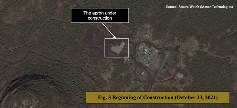
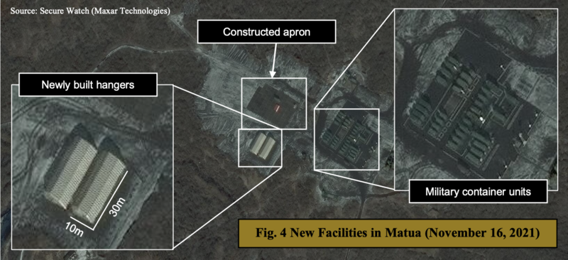
On the 22nd November 2021, the Japanese Research Center for Advanced Science and Technology (ROLES) produced a report saying the research base had been recently upgraded. Imagery in the report, from Maxar, showed that the base was still in the 2019 Google Earth configuration in September 2021, but by October it was well underway to becoming the new base.

Image from ROLES report. Original imagery from Maxar Technologies Secure watch

By November 16th it appeared to be complete, including two hangers that ROLES had measured at 30 metres in length. This is sufficient to take two K-300P TEL vehicles each – though it would be a tight squeeze.

Image from ROLES report. Original imagery from Maxar Technologies Secure watch

Please head to the ROLES website to view their report.

A short sequence shows inside what is probably one of the command vehicles though nothing of note is discernible. A keypad to the right of the screen states “INTERNAL COMMUNICATION” (ВНУТРЕННЯЯ СВЯЗЬ) used for secure coms between all the vehicles of the battery.

The remainder of the video shows two of the K-300P TELs (TEL 211 and TEL 214) taking a small tour of the South-eastern part of the island before deploying into two revetments back at the airfield.

48° 2’15.12″N 153°16’32.28″E

Capella Space Imagery

Whilst the news from the Russian MoD was interesting, it didn’t actually state any dates for when this deployment took place and whether it is still in operation. It had to be after October 23rd as the Maxar imagery in the ROLES report showed the base still under construction.

The Zvezda article had quotes from the Pacific Fleet: “On this remote island in the central part of the Kuril ridge, the Pacific Fleet’s missilemen will be on a 24-hour watch to monitor the adjacent water area and straits,” and “For the operation and maintenance of equipment, the equipment of technical posts has been installed, storage facilities for equipment and materiel have been deployed, entrances to the launch sites have been equipped,”

It also stated that work has been completed on the improvement of premises intended for year-round service and residence of personnel.

I wanted to check whether this was the case and so I put in an image collection request with Capella Space on the 2nd December 2021 at 1000 GMT.

From this request they were able to create a collection task for the 3rd December at 1236 GMT when the next pass took place – just 26 and a half hours later.

From comparing the video to revetment locations, it was a simple task to find where TEL 211 and 214 positioned themselves. This can also be easily done using Google Earth despite the age of the imagery available at this time. Very little has changed here except for the base.

However, the ability to task specific collection areas for future satellite passes meant an up-to-date 50cm resolution image was available for closer inspection.

Firstly, looking at the positions taken up by the TELs in the video these are now empty, though as a mobile system this is to be expected.

TEL 211 position

TEL 214 position

Main base

The main base does still show some sort of presence, though it is impossible to ascertain whether it is actually manned or not.

Whilst vehicles are present to the northeast of the hangers this doesn’t necessarily mean that they are being used. The Russian military store vehicles at locations for ease of a quick deployment should they decide to man them.

Though not shown here, the image available to me was for the complete southeastern area of the island and therefore all the areas commonly used when a deployment takes place. Again, there is little evidence to show any activity. There are no vehicles located at any of the revetments – likewise at the various locations to the north and south that could be used for not only the K-300Ps TELs but also any of the support vehicles carrying out any other tasks.

The concrete pad area is likely for supply storage, and this does appear to be empty.

However, with an +11 hour time difference between GMT and the region, this would mean that the local time when the collection took place was 2336 and therefore everything would probably be closed down for the night and little activity would be taking place anyway.

The fact that it was 2336, and therefore night time, highlights how useful the Capella SAR capability is. I was able to put in a request, and they were able to set up an image collection at the next available pass – despite it being dark. It could have been days before the next EO pass could be available from other providers.

This region is one of those that I regularly check so it will be interesting to keep an eye on it through imagery from Capella from time to time.

K-300P “Bastion-P” basic information

  • Anti-surface mobile coastal defence system
  • Consists of four TELs, each with two P-800 Oniks missiles, two Monolit-B mobile coastal surveillance radar vehicles, up to four loader vehicles, command and support vehicles.
  • Monolit-B has an approx range of 250 km in active mode, 240 km in passive mode
  • Can track up to 50 targets in passive mode, 30 in active
  • P-800: 6.9m in length; can cruise up to 2700 km/h at altitude; range between 120 km and 300 km depending on flight profile used; High cruise 46,000 ft, Low cruise 22 ft; 200 kg warhead
  • Command vehicle crew: 5
  • TEL crew: 3

Further information on Matua Island

The island itself is steeped in history, particularly for World War 2. All the trenches shown in the imagery are from that era. There’s a whole network of Japanese tunnels and bunkers located throughout the island; and reports that it was a potential test area for their nuclear weapons program that was being carried out at the end of the war.

A Zvezda video from 2017 on YouTube is well worth a watch – although it is obviously in Russian.

There’s also plenty of blogs and articles online that describe some of the research trips that have taken place there. To list a few:

https://zizuhotel.ru/en/bangkok/sekrety-matua-chto-skryvayut-nedra-kurilskogo-ostrova-yaponskuyu-krepost/


Murmansk-BN HF EW Complex

Murmansk-BN of the 475th Independent EW Centre near Sevastopol

Brief Murmansk-BN overview

Murmansk-BN has been operationally active from at least 2014 when the 475th Independent EW Centre of the Russian navy set up a complex in the Crimea south of Sevastopol. The system has a primary role of eliminating, or trying to eliminate, High Frequency (HF) broadcasts from NATO forces – in particular the HF Global Communications System of the United States (HFGCS).

HFGCS operates on well known HF frequencies with regular broadcasts of Emergency Action Messages (EAM’s) and other operational messages, phone patches etc. as required. To this date though, I am unaware of any reports that HFGCS has been interfered with by jamming. This in itself isn’t surprising. HF is a difficult thing to jam due to the very nature of using the ionosphere to carry the broadcasts. Throw in multiple frequencies in use at the same time, the same message being broadcast on numerous occasions, propagation and all other things related to HF reception means the message is likely to get through regardless of the attempts made to jam.

The Murmansk-BN complex is a fully mobile system and comprises of groups of up to four extendable antenna masts – two of which each on a dedicated Kamaz or Ural truck, which then tows a further antenna on a trailer. The masts extend to 32 metres in height. Each full Murmansk-BN complex normally has four of these antenna groups, making 16 antennas in total.

Further to that there are numerous support vehicles including a Kamaz 6350 Command vehicle and a Kamaz 6350 generator vehicle per four antenna group. Other vehicles include fuel bowsers and troop transport. Not always four antennas are used per group.

Murmansk-BN is in operation with units of both the Russian army and the navy – for the army with the 15th EW brigade in Tambov, 16th EW Brigade in Kursk, 18th EW Brigade in Yekaterinburg and 19th EW Brigade in Rassvet – for the navy with 186th Independent EW Centre of the Northern Fleet in Severomorsk, the 471st and 474th Independent EW Centres of the Pacific Fleet in Petropavlovsk-Kamchatsky and Shtykovo respectively, the previously mentioned 475th Independent EW Centre of the Black Sea Fleet in Sevastopol and the 841st Independent EW Centre of the Baltic Fleet in Yantarnyy.

It is highly likely that the 17th EW Brigade at Khabarovsk also has Murmansk-BN in operation but a this time I haven’t been able to locate any of the systems.

Screen grab from one of the Murmansk-BN videos showing an Icom IC- R8500 in use as the main receiver in each command vehicle
AOR 500 in a R330ZH Zhitel – image credited to
twower.livejournal.com

One aspect about the system is its use of analogue receivers rather than Software Defined Radio (SDR) technology – Icom IC-R8500 receivers have been noted in all the video footage available so far. This isn’t unusual for Russian EW systems – the AOR 5000 receiver is used in R330ZH Zhitel which is a mobile system primarily used in the jamming of satellite and cellular phone communication systems operated in the 100 to 2,000 MHz range. The AOR 5000 has multiple versions available, one of which has the cellular bands (824 to 849 MHz and 869 to 894 MHz) unblocked. Zhitel was used in the Crimean conflict with the high likelihood that the AOR 5000 was used to jam or intercept mobile phone communications. Recent reports have shown that Zhitel is still in use in the occupied Luhansk region.

I use an R8500 myself and it is an excellent receiver. I normally use it in conjunction with my SDR’s that provide me with a wider view of the HF bands so that I can search out signals. From the videos available online, the Russian military don’t do this but instead slow scan manually through the bands or scroll through frequencies saved to the receivers memory bank.

The receiver is linked to a PC using software that shows a visual spectrum taken from the audio output from the R8500, but this is limited to the mode in use. Video footage shows the likely use of AM mode to give as wide a visual spectrum as possible but this would be limited to the R8500’s 12 kHz maximum bandwidth. More on the software later.

The slow scan/memory scan method is not the best and would likely mean that any interception would be caught mid-way through a message. It is also time consuming. I am highly surprised there isn’t some sort of auto-scan software included. For instance I personally use df8ry’s CSVUserListBrowser to control not only my R8500 but most of my SDR’s. This can scan through stored frequencies on the Icom at a slow 1 second pace, but its better than sitting there turning a knob continuously for hours.

As the Icom is a receiver only, it needs to be linked to a transceiver using its CI-V remote jack point that then sends out the jamming signal – whether this then means another Icom transceiver is located within the command vehicle is unknown as, whilst confirmed from commentary and interviews with Russian personnel in the videos I found, there is no visual confirmation of what is used as the transmitter.

Each antenna group can operate individually or as multiples. Reports also state that the complexes can be integrated into the Russian EW command and control system.

The software

The software in use cannot be identified. It appears to operate like an automatic signals classifier, such as go2MONITOR by Procitec, but it is hard to assess whether it has this capability. It would be unusual not to have a classification capability, even if it meant manual selection of a signal.

There are a number of different screens, some tabulated, that control different functions, or provide different data.

One screen shows spectrum information split into four panels. The top panel shows the selected frequency, and what looks like audio taken from the Icom in AM-Wide mode – this differs from cuts to the Icom itself which shows it is in AM mode. If in AM-Wide it would mean the maximum audio spectrum available would be 12 kHz as this is all that the Icom can manage in this mode below 30 MHz, whilst AM would only produce a 5.5 kHz wide spectrum. However, using either of these modes would make it possible to visually obtain a signal from this.

What is interesting here though is that in the video, the top panel appears to show a bandwidth spread of 30 kHz with an area of 6 kHz in a lighter colour, possibly depicting the true area that a signal can be classified or monitored. 30 kHz is not a selectable bandwidth for the R8500 in any mode, with the maximum possible being 15 kHz above 30 MHz in WFM mode. Also of note is the noise floor indication which appears to be between -40dB and -50dB.

It could well be that this panel does not actually show a signal from the Icom, but could be the panel that shows the transmitter that produces the jamming signal.

The next two panels appear to show the signal with sensitivity information from the incoming audio. The final panel is unknown as it is not shown in any video close-up.

Another screen shows interface information to the bottom left. This has a number of tabs that control some the external elements that assist in the suppression of a signal. Connection status is shown by a green or red button.

Firstly, one tab shows the connection to a Protek KS-100M navigation device which is a GPS unit. This is connected to an antenna mounted to the top of the command vehicle and provides an accurate position for probable signal reception direction finding/triangulation purposes when connected to the other command vehicles KS-100M’s.

The KS-100M is also found in the Zhitel system as shown here in the far right panel. It is used for Direction Finding purposes in both systems – image credited to
twower.livejournal.com

To the left of the KS-100 tab are two unknown connections marked as ГТ-11and ГТ-11.1 (GT-11 and GT-11.1). ГТ in the Russian military is normally an abbreviation for rehepatop which translate to generator. In another part of one of the videos it shows the ГТ-11.1 title again, this time with four green boxes, each with what appears to be a tick box. Two of these appear to be connected as there is a joining line between them.

The final tab is unknown but marked as ГТ-205-ОПМ (GT-205-OPM) which if using the standard abbreviation format would also be related to a generator. However, the generator shown in the video appears to be named as an AD-100-T400-1R. Alternatively, you could break down the OPM part into two which would give supply (OP)/ engine (M).

What doesn’t quite tie up is that each four antenna group only has one generator, so does this section actually have something to do with the four antennas themselves and whether they have power going to them?

Above the four tabs is a box that is titled Information about current IRI. Below this is information on the signal being suppressed: Frequency – 9 961 02 kHz Type of target – unclassified Bandwidth – 3.36 kHz Duration – 16 msec Strength – 16 dB Bearing – 179 7 (1) – 0

This box is likely associated with the KS-100M tab.

The large window to the right shows what I thought at first was historic signal information in the selected bandwidth. However, looking closer I wonder if this is the case as the “signals” are too regular – they are evenly spaced. In other shots there are up to 20 signals shown. My thoughts are that these are connected to the KS-100M and are signal strengths of GLONASS GPS satellites. But again, without clearer screenshots or a confirmed ID on the software in use, this can only be guessed at.

There are numerous other tabs and screens available, but these are unreadable in the videos found.

Locations

The various units I have listed above. The sites used so far, despite Murmansk-BN being fully mobile, have been very close to the units home base. Despite the area required for a full complex deployment being large, they can be difficult to spot, but once you know the locations used – or the area – then it makes checking on them relatively easy.

The 15th EW Brigade at Tambov has not been observed on Google Earth (GE) as deployed as yet but the vehicles can be seen at their HQ at 52.666385N 41.537552E

Latest 15th EW Brigade site imagery near Tambov. Dated 13/11/18 and is the first time the Murmansk-BN was observed here.

The 15th EW HQ is situated in a large area of military ranges with plenty of surrounding free land available. It is presumed that this area will be used when setting up the complex. There is also an area to the NW that previously contained numerous antennas, but is now disused.

The 16th EW Brigade at Kursk uses a military training group for its deployment site. Only two antenna groups have been observed since first deployment in April 2015.

Latest 16th EW Brigade site imagery near Kursk at 51.713194N,
36.290736E. Dated 3/9/19

The 18th EW Brigade at Yekaterinburg is a very active unit with just two Murmansk-BN antenna groups in use at any one time according to GE imagery. Moreover, it seems to be a unit that likes to train in setting up the complex as it is quite often observed in different states. The Murmansk-Bn is spread over two sites – a permanent one (site one below) and a secondary site located in a field about 1.6km away (site two). In some imagery of site two only one antenna is up in two “groups” and quite often the site is empty.

The continuous erecting and disassembling of the complex’s could hint at the unit being involved in training. As shown in the image below it also tends to use truck mounted antennas at site two. There are no trailer mounted antennas visible, whilst they are in use at site one. However, the fact that there are six truck mounted here points to the 18th EW having a full compliment of Murmansk-BN equipment, despite only using two groups at the same time.

Murmansk-BN equipment of 18 EW Brigade at site two in a stored state

The 18th EW was also used in one of the videos. Comparing the video to GE imagery I was able to identify various features that confirmed that site two was used for the filming.

Site two confirmed as used in the Pravda.ru video

The 19th EW Brigade at Rassvet, near Rostov-on-Don, has had Murmansk-BN since at least 19/6/2016 when equipment first appeared in GE imagery at the HQ. Since then it would appear that it has not been deployed as the vehicles have stayed in a parked up state in all imagery from that date. The number of vehicles indicates only two groups have been allocated to the Brigade so far.

19th EW Brigade HQ in latest imagery dated 15/2/19

On the Russian navy side of things, the 186th Independent EW centre is based near Taybola at 68.515306N 33.290056E on the old airfield for the town. Taybola used to be a Soviet R-14 (SS-5 ‘Skean’) intermediate-range ballistic missile (IRBM) base with at least two silo complexes, a rail head, and the airfield.

The latest imagery on GE has just two Murmansk-BN groups set up at the northern end of the runway and old dispersal, but older imagery has a further group half way down the runway to the south.

GE imagery dated 18/8/17 showing the three locations of Murmansk-BN groups. the 186th has had the Murmansk-BN capability since at least 20/8/15 according to GE

The 471st Independent EW centre at Petropavlovsk-Kamchatsky, has a full complement of four Murmansk-BN antenna groups though it has had differing numbers in use since the system first arrived from at least 15/8/15. The latest imagery on GE below, dated from 3/11/18, shows just about a full complex in use. The NW group has one antenna missing.

471st Independent EW centre situated at 53.053583N 158.828178E

The 474th Independent EW Centre at Shtykovo, is also sited at a disused airfield. It has had three antenna groups in place at least once, but the latest GE imagery has just two in use.

The actual location of the 474th HQ is unknown and there no immediately close active military bases. There are numerous bases at a distance away, with a potential SIGINT site 12km to the SW. Analysis of these don’t provide any other Murmansk-BN vehicles.

The 475th Independent EW Centre is probably the most well known of the Murmansk-BN deployments. It is located to the south of Sevastopol in the Crimea at a coastal base and has been widely exposed on social media and articles since it became active. First shown in GE imagery dated 15/11/14 with one group, it has expanded to a full four group complex.

The 475th complex shown here, dated 26/8/18, with just the NW group active

It was news about the deployment of Murmansk-BN to the 841st Independent EW Centre at Yantarnyy in the Kaliningrad Oblast that drew my attention to the system. It is known that the 841st has a full compliment of four antenna groups but it is unusual to see all deployed. The image below, dated 11/9/17 is one of those times that it is fully active.

It is usually the northern site that is active when the 841st deploy. This is situated at 54.832506N 19.958467E. The “town” of Okunevo is actually a comms site.

The news I mention was reference the “new” deployment of Murmansk-BN to the Kaliningrad region, yet what is strange is that from GE analysis it is obvious the system has been in use there since at least 11/4/16 – so why this sudden hype? My only thought is that there was a major NATO exercise on in the region at the time which included USAF B-52’s carrying out Global Power missions from the US to Europe.

Was this news a counter to the US stating that Russian forces could interfere with their operations?

From all accounts, and from reported loggings of HFGCS messages since the Murmansk-BN system has been available for use, there has been zero suppression of any HFGCS frequencies that I’m aware of.

This then, with the fact that most units have not fully deployed their systems, makes me wonder whether Murmansk-BN is not quite so good as expected and claimed.

Here are the videos used for analysis:

This is the longer of the two videos and actually contains the second one.

https://www.yacoline.com/video/168091/

Second, shorter video showing the 186th Independent EW centre